 Foraminiferal
record of Holocene sea level
Foraminiferal
record of Holocene sea level
Collaborators: Roland Gehrels (University of Plymouth, U.K.); Kate Southall (Trinity College, Dublin); Ursula Cochran (GNS, Lower Hutt)
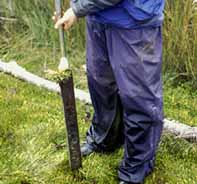
Foraminiferal distribution in high tidal salt meadows and salt marshes is strongly zoned with respect to tidal elevation. This zonation can be used to estimate (using transfer functions or modern analogue technique) the tidal elevation at which fossil Holocene foraminiferal assemblages once lived. High resolution studies of fossil foraminiferal faunas in cores of salt marsh peat can be used to reconstruct changes in sea level over the last 500-1000 years.
Our pilot study in southern New Zealand indicates 35 cm sea-level rise in the last 130 years. For further studies around New Zealand, we are focussing on the tectonically more stable coastal areas in New Zealand away from the earthquake-prone plate boundary deformation zone.
Study areas
a. South Otago (Pounawea, Catlins Lake) - partly published, 2006; published 2008.
b. Tasmania - field work undertaken, 2006. Gehrels led. Published 2011.
c. Southland (Mokomoko Inlet)- analyses underway, 2006-2015. Gehrels led
d. Eastern Southland (Waikawa Harbour) - completed by PhD, Brigida Figueira, 2012. Part-published 2014.
e. North-west Nelson (West Haven Inlet,and Golden Bay) - completed by PhD, Brigida Figueira, 2012.
f. Subantarctic Islands (Auckland Island) - reconnaissance undertaken, 2004, abandoned.g. Auckland (Puhinui, Manukau Harbour) – published 2012.
h. Coromandel Peninsula (Tairua) – analyses and dating complete, awaiting write-up (2015).
Publications
- Figueira, B., Hayward, B.W., 2014.
Impact of reworked foraminifera from an eroding salt-marsh front on
sea-level studies, New Zealand. New Zealand Journal of Geology and
Geophysics 57, 378-389.
- Hayward, B.W., Grenfell, H.R., Sabaa,
A.T., 2012. Marine submersion of an archaic moa-hunter occupational site,
Shag River estuary, North Otago. New Zealand Journal of Geology &
Geophysics 55, 127-136.
- Grenfell, H.R., Hayward, B.W., Nomura,
R., Sabaa, A.T., 2012. Proxy record of 20th century sea-level rise in the
Manukau Harbour, New Zealand. Marine and Freshwater Research 63, 370-384.
- Callard, S.L.,
W.R., G., Morrison, B.V., Grenfell, H.R., 2011. Suitability of salt-marsh
foraminifera as proxy indicators of sea level in Tasmania. Marine
Micropaleontology 79, 121-131.
- Gehrels,
W.R., Hayward, B.W., Newnham, R.M., and Southall, K.E., 2008, A 20th century acceleration in sea-level rise in New
Zealand. Geophysical Research Letters 35: L02717,
doi:10.1029/2007GL032632
- Southall,
K.E., Gehrels, W.R., and Hayward, B.W., 2006. Foraminifera in a New
Zealand salt marsh and their suitability as sea-level indicators.
Marine Micropaleontology, 60: 167-179.
- Hayward,
B.W., Grenfell, H.R., and Scott, D.B., 1999. Tidal range of marsh
foraminifera for determining former sea-level heights in New Zealand. New
Zealand Journal of Geology and Geophysics 42(3): 395-413.