West
Coast Region 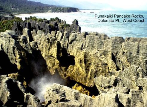
Abbey Rocks lithographic stone quarry. Map:
G36; Classification: B3. Significance: Only lithographic stone quarry in
Alborn coal mine, Reefton. Map: L30; Classification: C3. Significance: Well
preserved example of small scale coal mining operation on the West Coast.
Alexander Street Miocene
fossils. Map: J32; Classification: B5. Significance: Site contained
diverse Clifdenian fauna, but has now been destroyed.
Awatuna abandoned
marine cliffs, Kumara Junction. Map: J32; Classification: C3. Significance: One of the best preserved examples of old shorelines
along the West Coast.
Barrytown alluvial fans. Map: K31; Classification: C3. Significance:
Excellent examples of steeply sloping coastal fans.
Barrytown granite pluton and associated scheelite
deposit. Map: K31; Classification: C3. Significance: A good example of the
relationship between a granite pluton near its
original roof level and associated minerals.
Big River Gold Mine, Reefton.
Map: L31; Classification: B2. Significance: One of the best extant examples of
a large gold mining complex in
Blackball coalmining relics. Map: K31;
Classification: C2. Significance: Important historic mine site, well-preserved
examples of ventilation and boilerhouse chimneys.
Blackball scarps (flexural slip faults A,B,C). Map: K31; Classification: B3. Significance: Best
known example of flexural slip faulting in NZ.
Blackwater (Waiuta) gold mine, Reefton.
Map: L31; Classification: B2. Significance: The deepest and one of the largest
goldmines in
Blue Spur gold mining. Map: J32;
Classification: C3. Significance: Good example of fossil beach gold mining.
Brunner Gorge. Map:
K31; Classification: C3. Significance: Excellent example of a deeply incised
river gorge.
Brunner Industrial site.
Map: K31; Classification: B2. Significance: Remnants of one of the West Coast's
largest coal mines and associated coke ovens. Also the site
of
Buller Gorge. Map: L29; Classification: B3. Significance: One of
the most easily accessible, visually appreciated, major river
gorges in the
Buller Gorge
non-marine sedimentary sequence and plant beds. Map: L29; Classification: A3.
Significance: Type section of Ohika Formation; Stitts Tuff Member. Oldest post-Rangitata sediments on the West Coast, significant in
tectonics, paleogeography, palynology.
Good exposures of fluvial and lacustrine sediments. Internationally important Cretaceous plant beds.
Buller Gorge uranium
find. Map: K29; Classification: B2. Significance: First discovery of uranium
lode in NZ. Important because it focussed
attention on the Hawkes Crag Breccia
as a host rock for uranium mineralisation.
Bullock Creek semi-blind
valley. Map: K30; Classification: C2. Significance: Only example of a polje-like enclosed depression in the West Coast region.
Burnett Stream porphyry.
Map: L29; Classification: C2. Significance: Easily accessible and fresh
exposures of porphyry with abundant xenoliths.
Callaghans Creek Miocene macrofossils. Map: J32; Classification: C2.
Significance: Good exposure of fossiliferous Miocene
strata.
Callery Gorge. Map: H35; Classification: B3. Significance: A sawcut gorge of particular interest because of its
associated history.
Cascade morainic Plateau. Map: E38; Classification: C3. Significance: The
only substantial river mouth dune system and longest spit in southernmost
Cascade Point Pleistocene fossils. Map: E38;
Classification: C3. Significance: Only good late Pleistocene (Hawera Series) macrofossils from southern
Cavern Cave (Runanga
Cave / Dunollie Cave / Dragon Cave). Map: J31; Classification: C1. Significance: Best
known cave developed in calcareous sandstone of Island Sandstone
Formation. Contains
some speleothems and rare atypical cave fauna.
Charming Creek coal mine and tramway. Map:
L28; Classification: C2. Significance: A good example of an early coalmine and
tramway.
Clark Bluff folds.
Map: G37; Classification: C2. Significance: A good example of synmetamorphic ductile folds.
Cobden quarry Oligocene echinoids. Map: J31;
Classification: C3. Significance: Contains rich and diverse fossil echinoids.
Cowan Creek daqingshanite carbonatite. Map:
F37; Classification: A3. Significance: The world's second recorded occurrence
of the mineral daqingshanite.
Denniston Incline and coal workings. Map: K29; Classification: C2.
Significance: One of the earliest and most famous inclines in
Denniston Plateau. Map: K29; Classification: C3. Significance: A
barren rocky weakly dissected plateau. An attractive feature, formed due to the
existence of a near horizontal resistant rock layer.
Desolation Row columbite and gahnite. Map: L31; Classification: B3.
Significance: The only recorded occurrence of columbite
mineral in
Devastation Creek. Map: J35; Classification: C3. Significance: Good
example of a large scale rock slump.
Diorite Stream hanging valley. Map: E39;
Classification: C3. Significance: A good example of a hanging valley..
Dry Creek pseudotachylite. Map: I34; Classification: B3.
Significance: One of the best exposures of pseudotachylite
along the Alpine Fault.
Dublin Terrace fault scarp (Lyell Fault). Map: L29; Classification: C2. Significance:
Only existing flat area that lies along the trace of
the Lyell Fault.
Duffers Creek hapua,
Evans River Alpine Fault exposure.
Map: K32; Classification: C3. Significance: Good exposure of schist thrust west
over gravels on Alpine Fault.
Fern Flat granite.
Map: L29; Classification: C3. Significance: Type locality of the Fern Flat
Granite.
Five Mile dredge tailings.
Map: H35; Classification: C2. Significance: Only successful hydraulic powered
dredge operation on the West Coast.
Fourteen to Seventeen Mile Bluffs folding.
Map: J31; Classification: B3. Significance: Very good examples of folding and
cleavage features.
Fox glacier. Map: H35; Classification: A3. Significance: The
most easily accessible glacier on the West Coast. One of the
two best known tourist glaciers in
Fox Glacier glacierised
surface. Map: H35; Classification: C2. Significance: An easily accessible and
excellent example of an area of glacierised surfaces.
Fox Glacier rockfall. Map: H35; Classification: C3.
Significance: A good example of a small rock fall.
Fox River Cave/Armageddon
Cave. Map: K30; Classification: C3. Significance: One of largest cave
systems in New Zealand. Good example of joint control in passage development.
Fox River mouth Hawks Crag Breccia.
Map: K30; Classification: C3. Significance: Good coastal exposure of the Hawks
Crag Breccia.
Fox River Springs. Map: H35; Classification:
C2. Significance: One of just a few warm springs on teh
West Coast.
Franz Josef glacier. Map: H35; Classification: A3. Significance: One
of the two most visited tourist glaciers in New Zealand.
Franz Josef glacierised
surfaces. Map: H35; Classification: B2. Significance: Easily accessible, well
preserved surface recently exposed by retreat of glacier.
Gaunt Creek Alpine Fault overthrust
exposure. Map: I35; Classification: A3. Significance: Large exposure of Alpine
Fault showing gravels overthrust by schist.
Gentle Annie Point Oligocene structures. Map: L28;
Classification: C3. Significance: Good example of folding and faulting.
Granity coke ovens. Map: L28; Classification: C2. Significance:
Example of local stone use in coke oven construction.
Grey River Eocene sandstone
and coal measures. Map: K31; Classification: B3. Significance: Well
exposed Eocene sedimentary sequence and formation type locality.
Haast relict dune sequence. Map: F37; Classification: B2.
Significance: One of the best New
Zealand examples of a complete sequence of Holocene relict foredune
ridges and intervening swamps in a pristine environment, showing gradual
advancement seaward over the last 8000 years. Only
significant flat coastal region in the South-West New Zealand World Heritage
Area and the most extensive wetland area in
Hare Mare Creek Alpine Fault overthrust. Map: H35; Classification: A3. Significance:
Most easily accessible large exposure of Alpine Fault overthrust.
Haupiri River Springs. Map: K32; Classification: C2. Significance:
Hawks Crag breccia. Map: K29; Classification: C3. Significance:
Good exposure of the contact between coarse alluvial fan Hawks Crag Breccia and finer alluvial Ohika
Formation.
Hawks Crag inselbergs. Map: K29; Classification: C3.
Significance: Spectacular steep-sided round-topped hilly protrusions. An unusual landform in
Heretaniwha Point moraine bluff,
Hikimutu Lagoon hapua,
Hochstetter Dam,
Hokitika Gorge migmatite gneiss. Map: J33;
Classification: C2. Significance: Rare example of partially melted
granite-gneiss.
Hokitika Tailings goodletite. Map: J32;
Classification: B2. Significance: Goodletite rock - a
mixture of massive mica, tourmaline and ruby.
Honeycomb Hill natural
bridge,
Honeycomb Hill Holocene cave
system,
Ikamatua alluvial terraces. Map: K31; Classification: C3.
Significance:
One of the two best sets of alluvial terraces on teh
West Coast.
Imp Grotto Haast
Schist antiform exposure. Map: F37; Classification:
C3. Significance: Key exposure for the identification of the antiformal macroscopic fold hinge in Haast
Schist.
Inangahua Earthquake
slip scar. Map: L29; Classification: C3. Significance: The most prominant and easily visable
result of the 1968 earthquake. Blocked the
Inangahua Junction
1968 fault scarp (Glasgow Fault). Map: L29; Classification: C2. Significance:
Recent scarp uplifted during the Inangahua earthquake
of 1968 along the Glasgow Fault.
Inchbonnie en-echelon fault scarps (Alpine Fault). Map: K32;
Classification: B2. Significance: Excellent example of en-echelon fault scarps
displacing alluvial terrace and channels.
Ivory glacierised
surfaces and
Kaiata Creek Eocene fossil sequence. Map: K32; Classification: C3.
Significance: Well exposed sequence of fossiliferous
Eocene strata, that was selected as the name bearer
for the New Zealand Kaiatan Stage.
Kaka Creek Alpine Fault
exposure. Map: J34; Classification: A3. Significance: Rare locality
where thrusting rate has been determined for the Alpine Fault.
Kaniere River Pliocene fossils. Map: J33; Classification:
C4. Significance:
Site of rich and diverse Pliocene (Opoitian Stage)
fossils.
Kapitea Creek Miocene macrofossils. Map: J32; Classification: B3.
Significance: Well exposed fossiliferous sequence
through latest Miocene strata that has been selected as the type reference
section for this period of time in
Karamea-Otumahana double estuary. Map: J27;
Classification: B2. Significance: A large coastal double estuary enclosed by sandspits and barrier islands. One of the
largest estuarine systems on the West Coast.
Karoro Brickworks Miocene fossils. Map: J32; Classification: B1.
Significance: Diverse and rich middle Miocene (Waiauan)
fossils.
Kawhaka Dam. Map:
J33; Classification: C2. Significance: Example of early water supply dam for
industrial use.
Kehu Stream fluorite. Map: K29; Classification: B3.
Significance: Rare and extensive example of fluorite mineralisation.
Kelly Saddle fault traces and ridge rents.
Map: K33; Classification: B2. Significance: One of the best exposed patterns of
fault traces affected by gravity movements.
Kini Creek kyanite. Map: G36;
Classification: C3. Significance: The only kyanite
locality in Haast Schist.
Knights Point marine
terrace. Map: F36; Classification: C3. Significance: Good example of one
of the few marine terrace remnants on this stretch of coast.
Knights Point stacks. Map: F36;
Classification: C3. Significance: One of
the most commonly viewed examples of rocky stacks along the spectacular coastline
of
Kohaihai Bluff Oligocene shallow water fossils. Map: L26;
Classification: C3. Significance: One of the few shallow water early Oligocene
(Whaingaroan) molluscan
fossil faunas in
Kokatahi River Springs. Map: J33; Classification: C2. Significance:
One of few hot springs on the West Coast
Kotuku oil seep. Map:
K32; Classification: C3. Significance: First oil discovery in the
Kumara goldfield.
Map: J32; Classification: C3. Significance: Last major goldfield discovered on
the West Coast.
La Perouse moraine. Map: H36; Classification: B3. Significance:
Excellent example of a sequence of moraine loops at toe of a glacier.
Lake Rotoiti moraine dam. Map: N29; Classification: C3. Significance: An
excellent example of a moraine-dammed lake with a sequence of terminal moraine
showing sucessive glacial advances during the late
Pleistocene.
Langdon's Reef antimony
mine, Greymouth. Map: K31; Classification: B2.
Significance: A rare example of attempts to mine antimony in
Lankey Creek Devonian fossils. Map: L30; Classification: A2.
Significance: One of the best sequences of rare fossiliferous
Devonian strat in
Little
Little Wanganui
River Pliocene fossils. Map: L27; Classification: C3. Significance: Site
of rich and diverse Miocene-Pliocene macrofossils, the youngest in northern
Loopline terminal moraine. Map: J32; Classification: B2. Significance: A
well defined example of a terminal moraine. Major type
location for the definition of glacial stages in
Lyell Creek gold workings. Map: L29; Classification: C3.
Significance: Good example of historic gold workings on the West Coast.
MacPherson Creek mylonites. Map: J33;
Classification: C3. Significance: Good example of mylonitised
granitic rocks associated with the Alpine Fault.
Mahinapua dune field. Map: J33; Classification: C2. Significance: One
of the most complete dune sequences on the West Coast.
Maruia Basin en echelon fold. Map: L31; Classification: B3.
Significance: An example of folding related to dextral shear associated with
the Alpine Fault.
Maruia Hot Springs.
Map: M31; Classification: C2. Significance:
Maruia Paleozoic fossils. Map: M31;
Classification: B3. Significance: Unique sequence of strata spanning upper
Cambrian to upper Ordovician with rich conodont, mollusc and graptolite fossils.
McLaughlins Pit crossbedded sand. Map: K29;
Classification: B2. Significance: Easily accessible exposure of cross bedded quartzose sand.
Mitchell's Gully gold
workings. Map: K29; Classification: C1. Significance: Very good example
of workings in raised beach deposits with tunnel excavations.
Moana lateral moraine. Map: K32; Classification: B3.
Significance: An easily seen example of a long narrow sinuous moraine standing prominantly above an outwash plain.
Moonraker Antiform chevron folding. Map:
E39; Classification: C3. Significance: A classic example of chevron folds in
layered rocks.
Moria Gate limestone natural bridge,
Motukiekie Rocks and shore platform, Twelve Mile Bluff. Map: J31; Classification:
C3. Significance: One of the West Coast’s most dramatic and most easily
accessible coastlines.
Mt Albert fenite. Map: L31; Classification: B3. Significance:
Best example of only two known occurences of alkali-metasomatism in
Mt Ashmore
alluvial fan. Map: I34; Classification: C3. Significance: A visually
striking example of an alluvial fan adjacent to main highway.
Mt Durward
quartz vein. Map: I34; Classification: C3. Significance: An unusual and
well-exposed example of quartz veining
Mt Garibaldi karst. Map: M27; Classification: C3. Significance:
Spectacular karst plateau eroded in Tertiary
limestone.
Mt Harry cataclasite.
Map: J33; Classification: C3. Significance: An excellent example of cataclasite associated with the Alpine Fault.
Mt Inframeta Pounamu Ultramafics. Map: J34;
Classification: A3. Significance: The best exposure of the Pounamu Ultramafic belt, metamorphosed ultramafic
rocks. Largest naturally occurring diopside crystals
in
Mt La Perouse folded
schist. Map: H36; Classification: B3. Significance: An example of a large scale
fold in the Alpine Schist.
Mt Misery cirques. Map: M28; Classification: B3. Significance:
Spectacular cirques are cut into rounded mountains providing
a "biscuit board topography".
Mt Radiant copper-molybdenum
mine. Map: L28; Classification: B3. Significance: Only molybdenum mine
in
Mungo River Springs. Map: J34; Classification: C2. Significance:
Cluster of three
Murchison 1929 road
displacement. Map: L29; Classification: C2. Significance: Well known
site of fault scarp that displaced the main highway during the 1929 Murchison
earthquake.
Murray Creek gold mines. Map: L30;
Classification: C2. Significance: Site of first successful gold-bearing quartz
mines on the West Coast.
Ngahere tailings. Map: K31; Classification: C2. Significance: Well
preserved example of dredge tailings.
Ngakawau Gorge. Map:
L28; Classification: C3. Significance: The deepest and most spectacular coastal
river gorge on the West Coast.
Nine and Twelve Mile Bluffs coal measures.
Map: J31; Classification: C3. Significance: Spectacular 60 m vertical cliffs
exposing prominant tilted bands of coal measures,
conglomerate and sandstone, from Greenland Group through two members of Paparoa Coal Measures.
Ohika hydrothermal metamorphism. Map: K29; Classification: B4.
Significance: A unique example of hydrothermal metamorphism associated with a
major detachment fault.
Okarito Lagoon. Map:
H34; Classification: C3. Significance: One of the best examples on the West
Coast of a coastal lagoon enclosed by a gravel barrier.
Oparara natural bridge (Oparara Arch). Map: L27; Classification: B3.
Significance: Largest limestone natural bridge in
Oparara Quarry granite. Map: L27; Classification: B3. Significance:
An easily accessible quarry exposure of the Karamea
Granite.
Orowaiti raised
terraces. Map: K29; Classification: B3. Significance: Classic
O'Sullivans granite. Map: L29; Classification: C3. Significance:
Typical example of a number of more evolved Karamea
Suite plutons.
Otehake River Springs. Map: K33; Classification: C2. Significance:
One of few hot springs on the West Coast.
Otira River Springs. Map: K33; Classification: C2. Significance:
One of few warm springs on West Coast.
Oweka rock block
slide. Map: L29; Classification: C3. Significance: Very good example of an
earthquake triggered, dated block slide which exists at a very low angle.
Paringa Fold (Alpine
Fault). Map: G36; Classification: B3. Significance: Good example of active upwarping of aggradation surface
along Alpine Fault
Paringa volcanic breccia. Map: G36;
Classification: C3. Significance: Example of slump deposit from actively
erupting submarine volcano.
Payne Creek granodiorite. Map: L29;
Classification: C3. Significance: Complete section through a single intrusion.
Perpendicular Point Eocene
crab and echinoid fossils. Map: K30; Classification: A3. Significance:
'Crab bed' with fossil fauna of diverse crabs and echinoids. One
of richest fossil crab localities in
Perpendicular Point vertical
sea cliff. Map: K30; Classification: C3. Significance: A prominent 30 m
high vertical sea cliff capped by a flat marine terrace.
Point Elizabeth mid Tertiary
fossiliferous sediments. Map: J31;
Classification: B3. Significance: Excellent, well-exposed section through a
late Eocene and Oligocene sequence of strata that have been selected as the
type reference section for this period of time in
Porarari River uranium. Map: K30; Classification: C3. Significance: Rare
occurrence in
Punakaiki pancake
rocks, Dolomite Point. Map: K30; Classification: B2. Significance: Spectacular
and unusual thinly plated limestone eroded by the sea ('Pancake Rocks'), and
blowholes, which have become a prominant tourist
attraction.
Punakaiki River cordierite. Map: K30; Classification: C3.
Significance:
A rare occurrence of fresh cordierite mineral.
Rainy Creek Devonian fossils.
Map: L30; Classification: A2. Significance: One of the best fossiliferous
Devonian sequences in
Rewanui Incline and
coal mines. Map: K31; Classification: C2. Significance: A well preserved and
accessible example of a major coal mine on the West Coast.
Ross alluvial gold mine.
Map: J33; Classification: C3. Significance: Good example of a deep lead
alluvial gold mine; an example of the early industrial use of electricity.
Rotomanu roche moutonnee. Map: K32; Classification: C2. Significance:
Three roche moutonnee, the
largest one 100 m high, important as they are easily accesible
and easily seen.
Sabot Creek, Bald
Saddle Creek blastomylonite. Map: J33; Classification: C3.
Significance: Blastomylonite
Saltwater Lagoon,
Selbourne Spur
uplifted wave cut platforms (Alpine Fault). Map: F38; Classification: B3.
Significance: Well preserved examples of some of the 11 terrace levels recognised along the
Shamrock Creek gold
workings. Map: J32; Classification: C3. Significance: Site of early gold
rush, good example of a variety of gold workings.
Shantytown gold workings.
Map: J32; Classification: C3. Significance: Good representative example of
beach lead workings against a fossil cliff.
Ship Creek basalt.
Map: F37; Classification: C3. Significance: Well exposed and good example of
columnar-jointed basalt lava flow.
Slippery Rock Alpine Fault
exposure. Map: H35; Classification: B3. Significance: Easily accessible
exposure of Alpine Fault and offsets of ice-smoothed rock faces.
Smith Gorge, Fraser Complex. Map: J33;
Classification: C3. Significance: Evidence for deep-level movement on the
Alpine Fault.
Speargrass Fault Zone. Map: N29; Classification: A3. Significance:
Part of the Median Tectonic Zone (eastern contact of Median Batholith),
an excellent example of fault rocks.
Springs Junction Devonian
road section. Map: L30; Classification: A3. Significance: One of the
best and most easily accessible Devonian sequences in
Stony Creek lime kiln, Reefton.
Map: L30; Classification: C2. Significance: One of the few surviving lime kilns
on the West Coast.
Strongman Mine. Map:
J31; Classification: C4. Significance: Largest underground coal mine in the Greymouth Coalfield.
Taipo Spur molybdenite. Map: M28;
Classification: B3. Significance: A spectacular occurrence of molybdenite.
Tansey Moraine section, Brunner Anticline. Map: J32; Classification:
C3. Significance: Excellent example of active folding of young aggradation surface.
Taramakau serpentinite stone quarry. Map: K33; Classification: C3.
Significance: Only attempt to mine serpentinite as a
building stone in
Taramakau tailings. Map: J32; Classification: C3. Significance: One
of the best examples of gold mining dredge tailings sites on the West Coast.
Tauranga Bay tombolo, Cape Foulwind. Map: K29; Classification: C3.
Significance: The only significant tombolo on the
West Coast.
Te Ana Puta Cave, Point Elizabeth. Map: J31; Classification: C2. Significance: Both a sea cave
and karst cave.
At high tide, the visual, sound and air compression effects in the
second sea cave, when viewed from the inner cave above, make this cave unique.
Te Miko coastal section, Punakaiki. Map: K29;
Classification: C3. Significance: Spectacular section of rocky coast, pocket
beaches and large sea caves carved into fossiliferous
limestone.
Te Tahi Cave, Charleston. Map: K30; Classification: C2. Significance:
Fossil whale bones in limestone exposed in cave. Good example of horizontal vadose streamway. Easily accessible.
Three Mile Hill roche moutonnee. Map: J32;
Classification: C3. Significance: Good example of roche
moutonnee hill.
Three Steeples stacks and
Black Reef,
Tiropahi alluvial terraces. Map: K30; Classification: C3.
Significance:
An extensive flight of at least five alluvial terraces over a distance of 5 km.
Important as it is a complete alluvial sequence.
Tiropahi gorge. Map: K30; Classification: C2. Significance: An
unusual deep coastal gorge cut through limestones.
Torea Rocks brecciated granite. Map: L28; Classification: B3.
Significance: Type of breccia unique in
Totara Lagoon hapua, Ross. Map: J33;
Classification: B2. Significance: One of the longest hapua
in
Trig FZ exposure of Alpine Fault. Map: M31;
Classification: B2. Significance: Good exposure of Alpine Fault with schist overthrust on granites.
Uranium Creek coffinite. Map: K29; Classification: B3.
Significance: One of best examples in
Waikukupa thrust
complex. Map: H35; Classification: A3. Significance: One of the best examples
in the world of duplex structures on an active fault.
Waitahu River Devonian section. Map: L30; Classification:
A2. Significance:
One of best exposed Devonian sequences in
Wanganui River Springs. Map: I34; Classification: C2. Significance:
One of several warm springs in area.
Westport marine terraces. Map: K29; Classification: C3. Significance: Best
West Coast examples of raised marine terraces.
Whakapoai Point fluorite. Map: L26; Classification: B3. Significance:
One of the best exposures in
Whale Creek granite.
Map: L29; Classification: C3. Significance: Typical example of the more mafic varieties of granite in the Karamea
Suite.
Whataroa (
White Creek Fault displaced terraces. Map:
L29; Classification: B2. Significance: Easily seen terrace sequence faulted by
single (Murchison Earthquake) movement on the White Creek Fault.
White Horse Creek ultramylonites. Map: K30; Classification: B3.
Significance: The best example of ultramylonitised granitoid rocks in
White Horse Creek uplifted sea cave. Map: K30;
Classification: C1. Significance: A sea cave several metres
above present sea level, from which Quaternary uplift can be estimated for this
part of the Buller District.
Whitecliffs bluffs.
Map: L29; Classification: C3. Significance: Inland 30-100 m high easily visable white limestone bluffs.
Whitecliffs Oligocene hardground. Map: L29;
Classification: C3. Significance: Well exposed phosphatisd
and nodular shellbed and hardground.
Woods Creek alluvial gold
workings. Map: K32; Classification: C2. Significance: Good example of
underground alluvial mining.
Xanadu CaveBullock CreekCave
Creek South. Map: K30; Classification: B3. Significance: Excellent
example of phreatic maze development.
Yorkey Creek Devonian fossils. Map: L30; Classification: A2.
Significance: One of just a few good Devonian fossil areas in