Wellington 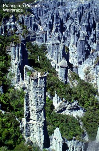
Baring Head marine terraces.
Map: R28; Classification: B3. Significance: A series of at least two
distinctive uplifted marine terraces - the largest and most distinctive set in
the
Basin Reserve. Map: R27;
Classification: C3. Significance: An easily interpreted uplifted remnant from
the biggest earthquake to have hit
Battery Hill abandoned gravel bar. Map: R27;
Classification: B2. Significance: One of the best examples in
Big Hill earth pillars, rills and gullies.
Map: S28; Classification: B3. Significance: A growing area of disturbance in
which all sequential stages of erosion are present. The best
area in
Carterton Fault, Blairlogie Road trace. Map: T26;
Classification: C3. Significance: Late Quaternary trace of the Carterton Fault showing 7.6-15.2 m RL displacement.
Castlepoint coastal features. Map: U26; Classification: B3.
Significance: One of the most well-known, most complex and well-documented
landforms on the
Castlepoint marine terrace. Map: U26; Classification: C3. Significance:
Castlepoint Pleistocene sediments. Map: U26; Classification: B3.
Significance: Important fossil content, recording change in climate conditions
during Ice Ages.
Colonial Knob uplifted peneplain.
Map: R27; Classification: C3. Significance: Kaukau
erosion surface remnant.
Dry River Fault,
Eparaimu uplifted
marine benches,
Galatea Mine gold.
Map: R27; Classification: C3. Significance: Good examples of visible gold.
Glenburn dike. Map: T28; Classification: C3.
Significance: Well exposed, "classic" dike.
Glenburn tilted marine benches. Map: T27;
Classification: B3. Significance: One of the best and most easily accessible
examples of well-preserved Holocene marine benches along the southeastern Wairarapa coast. Southern limit of the
only known example of active folding in
Government Life Insurance
building. Map: R27; Classification: B1. Significance: One of the largest
and best examples of the use of Coromandel Tonalite in a building.
Haurangi Hairpin Plio-Pleistocene limestone.
Map: S28; Classification: B3. Significance: Pliocene-Pleistocene sequence of
limestone.
Haurangi Hairpin karst, SE Wairarapa.
Map: S28; Classification: C3. Significance: Only known limestone pavement in
the southern Wairarapa region. Sinkholes are sporadic in the wider Haurangi-Ruakokoputuna-Makara area.
Haywards Hill Pleistocene kauri pollen locality. Map: R27;
Classification: C2. Significance: Quaternary lacustrine
sediment with kauri showing evidence of temperate montane
conditions in
Hikurangi Margin thrusts. Map: NA; Classification: B3. Significance:
Major basin ridge fault of 9 at the Hikurangi Subduction Zone. A major seaward facing fault scarp
(>500 m high) dividing underthrusting Pacific
plate cover sediments from highly contorted Australasian plate sediments. Can
be traced for over 120 km on NE trend. General Hikurangi
Margin area has en echelon thrusts and folds.
Honeycomb Rock unusual weathering pattern.
Map: T28; Classification: C1. Significance: One of the most spectacular and
most easily accessible examples of honeycomb weathering along the Wairarapa coast.
Huangarua Fault.
Map: S27; Classification: C3. Significance: Scarp of the Huangarua
Fault (splinter of the Dry River Fault) displacing c.10000 year Ohakean terraces. The fault passes into an asymmetric
anticline to NE, and terraces of unknown age (>Ohakean,
<Porewan) displaced close to Huangarua.
Huangarua Syncline
flexural slip faults. Map: S27; Classification: B3. Significance: Very clear
example of late Quaternary flexural slip faulting on steep NW limb of Huangarua Syncline, adjacent to Huangarua
Fault. Exposure of unconformity at the base of Te Muna
Formation offset by flexural slip faulting of up to 20-40 m SE side up.
Faulting has not offset Waiohine Surface (Huangarua Fault offsets this surface by 6 m, NE side up).
Hutt Motorway
landslide. Map: R27; Classification: C3. Significance: Largest landslide in
Hutt River alluvial terraces. Map: R27; Classification:
C3. Significance:
A good sequence of alluvial terraces.
Kaiwhata Stream sills. Map: T27; Classification: C2. Significance:
Well-studied sills; key part of Ngahape Complex.
Kapiti Island phyllonite. Map: R26; Classification: C3. Significance: An
excellent example of phyllonite developed by intense cataclastic metamorphism.
Kerosene Bluff black shale. Map: U26;
Classification: C2. Significance: Good, easily accessible exposure of rare Waipawa Black Shale with smell of kerosene.
Kilbirnie tombolo. Map: R27; Classification: B3. Significance: One of the largest tombolos
in
Kourarau freshwater fossils. Map: T27; Classification:
C1. Significance:
One of just a few examples of young freshwater sediment deposits containing rich
freshwater mollusc and ostracod
fossils.
Kupe's Sail sandstone slab. Map: S28; Classification: C2.
Significance: A huge resistant slab of sandstone is exposed on the coastal
cliff in a sail-like shape.
Leper Island sea arch. Map: R27;
Classification: C2. Significance: Small sea arch of historical significance as
home to Chinese "leper".
MacKays Crossing
abandoned sea cliff, Kapiti Coast. Map: R26;
Classification: C3. Significance: Scarp formed by the post-glacial sea when it
reached its maximum line of transgression. A well-defined landform of
educational nad scientific value.
Makara Pliocene
sedimentary outlier. Map: R27; Classification: B2. Significance: Best exposure
of the only outcrop of Pliocene age on
Mangaopari
Miocene-Pleistocene paleomagnetic section. Map: S27;
Classification: A3. Significance: One of the standard paleomagnetic
sections for the world, closely tied to the biostratigraphy.
Diverse bathyal molluscs of
Tongaporutuan age.
Marble Arch, Pukerua
Bay. Map: R26; Classification: C2. Significance: Small uplifted sea arch of
educational value.
Masterton Fault (Waingawa Fault). Map: S26; Classification: C2.
Significance: Late Quaternary trace of the Masterton
Fault and associated graben feature. Swampy area NNW
of the freezing works is formed in a graben where the
fault forms a minor branch. Vertical displacement is S side up in the W, and N
side up in the E. Scarp height is c.4-5 m (typically N side up).
Mataikona climbing dunes, northern Wairarapa
coast. Map: U25; Classification: C2. Significance: Most extensive area
of few active dunes between
Mangapakeha gas
vents and mud volcanoes. Map: T26; Classification: C1. Significance: Possibly
the best example of a small mud volcano in the
McClouds Trig rock slump. Map: T26; Classification: B3.
Significance: Earthquake triggered rock slump comprising multiple rotational
blocks with flow features at the toe.
Moa Pt sea arch. Map: R27; Classification: C1.
Significance: Small, easily accessible sea arch through greywacke point.
Mukamuka pillow breccia. Map: R28; Classification: C3. Significance:
Possibly the best example of pillow breccia in
basement of southern North Island.
National Carillon and Hall of Memories. Map:
R27; Classification: C2. Significance: Easily accessible examples of the use of
a wide variety of NZ stone.
National Museum. Map: R27; Classification: B1.
Significance: Largest and most important surviving building made of Putaruru Ignimbrite.
Ngapotiki alluvial
fan. Map: S28; Classification: C3. Significance: A large (500 m x 300 m)
alluvial fan.
Ohariu Fault
(previously Kakaho Fault), Kakaho
Valley, Pauatahanui. Map: R26; Classification: C3.
Significance: Late Quaternary right lateral displacement of ridges, alluvial
fans and terraces along the Ohariu Fault. 1 m recent
vertical displacement (W side up) on fault and displacement rate of 0.06 mmyr over last 18000 years. Offset streams show 17.6 m RL displacement,
giving rate of 1-1.8 mmyr. Larger 250 m displacements
up valley indicate longer term progressive displacement. No activity on this
section of fault in last 1650 years.
Ohariu Fault, Muaupoko Valley. Map: R26; Classification: C3. Significance:
Recent trace of the Ohariu Fault. Displaced terrace
and ?tectonic bulges.
Ohariu Fault, Ohariu Valley Road. Map: R27; Classification: C2.
Significance: Recent 2-3 m high scarp formed around 200 years ago by rupturing
along the Ohariu Fault. Displacement
W side up.
Okupe Lagoon
uplifted lagoon. Map: R26; Classification: C2. Significance: One of the best sites for studies of late Holocene
tectonic uplift in the
Old Parliament buildings and
foyer. Map: R27; Classification: B2. Significance: Largest and most
important building made of Nelson Marble.
Otaihanga Oligocene
sedimentary outlier. Map: R26; Classification: C2. Significance: Only locality
where Oligocene sedimentary environments can be determined in the Wellington
area including East Coast to Wanganui.
Otaki beach ridges.
Map: R25; Classification: C3. Significance: Localised
gravel beach ridges demonstrating the influence of coarse sediment supplied by
the Otaki River compared with the rivers further
north. Coarse material affects the degree of dune development down the coast.
Otaki Forks Triassic
Monotis fossils. Map: S26; Classification: C3.
Significance: Regionally important for the presence of Monotis-bearing
localities in generally unfossiliferous Torlesse greywackes.
Paekakariki rockfall. Map: R26; Classification: C3. Significance:
Paraparaumu cuspate foreland. Map: R26; Classification: B3.
Significance: By far the largest and most prominent cuspate foreland in
Pauatahanui Inlet, Porirua Harbour. Map: R26;
Classification: C3. Significance: Largest relatively unmodified estuary
and largest salt marsh in the lower
Public Trust building,
Pukemuri Stream
uplifted marine benches. Map: S28; Classification: B2. Significance: Well
preserved sequence of 7 uplifted Holocene marine terraces that record uplift
history of Wairarapa coast. 3540 year date for
terrace 5. Most well preserved sequence of this section of coast.
Pukerua Fault, Pukerua Bay area. Map: R26; Classification: C3.
Significance: Sites of late Quaternary displacements along the Pukerua Fault. Displacement rates of 1.1 mmy RL and 0.14 mmy vertical (E
side up). This vertical motion is in opposite sense to long term W side up
motion. Features comprise scarps, offset ridges and springs.
Putangirua
Pinnacles. Map: S28; Classification: B2. Significance: The best area in
Quartz Hill uplifted peneplain.
Map: R27; Classification: C3. Significance: Kaukau
erosion surface remnant. Largest relatively uneroded peneplain remnant in the
Radiata Grove red weathered
site, Wellington. Map: R27; Classification: C3. Significance: Outcrops indicate
periodic episodes of much warmer conditions during the Quaternary than at
present, and associated with the Mangaroa (Rangitawa Ash) dated at about 0.35 ka.
Red Rocks Permo-Triassic
terranes, pillow lavas and thrusts. Map: R27;
Classification: B1. Significance: Well exposed, easily accessible, educational
section with diversity of lithologies - chert, argillite and pillow lava. Best exposed and most
accessible of the pillow lavas in the Torlesse in the
southern North Island. Evidence of imbrication in the
Torlesse terrane.
Rock Point Triassic worm tube fossils. Map:
R27; Classification: B2. Significance: Type locality of Titahia
corrugata, found together with Torlessia
(both worm tubes) in Torlesse greywackes.
Ruakokopatuna Gorge,
Martinborough. Map: S27; Classification: C3. Significance: Spectacular narrow gorge in limestone, about 1 km
long.
Shepards Gully Fault - 1. Map: Q27; Classification: C3.
Significance: Largest RL offset on the Shepherds Gully Fault of 400 m, from
offset of deeply incised streams.
Shepards Gully Fault - 2. Map: Q27;
Classification: C3. Significance: Late Quaternary displacements along the
Shepherds Gully Fault. Record of Holocene displacements at site of c.3.5-4 m RL
and 0.4 m vertical (NW side up).
Somes Island sea
arch. Map: R27; Classification: C2. Significance: Small, easily visible sea
arch
South Waiohine fault
bulge. Map: S26; Classification: B2. Significance: Excellent, easily viewed
example of a bulge produced by a jog displacement on a major active fault.
Sunnyside Miocene
conglomerate. Map: S27; Classification: C3. Significance: Basal beds in
widespread late Miocene transgression (equivalent in part to Hurupi Formation)
Te Horo abandoned
sea cliff. Map: R25; Classification: C3. Significance: An abandoned sea cliff
representing the time of maximum post-glacial sea level.
Te Kaukau Point Paleocene Amuri Group sediments. Map: S28;
Classification: C3. Significance: Well exposed sedimentary sequence of the Amuri Group in the Wairarapa
region.
Te Ramaroa alluvial
fan, MacKays Crossing, Kapiti
Coast. Map: R26; Classification: C3. Significance: A small, very well defined,
example of a landform with obvious educational and scientific value.
Terawhiti gold
mining sites. Map: Q27; Classification: C2. Significance: A good example of
gold mineralisation in greywacke. One of the few
sites of extensive gold prospecting in the lower half of the North Island.
Terawhiti Hill,
Black Gully uplifted marine terraces. Map: Q27; Classification: C3.
Significance: Sequence of 7 raised marine benches that record uplift history of
SW Wellington coast. This site is monitored for precise strain measurements by
the Earth Deformation Section, Institute of Geological and Nuclear Sciences Ltd
(New Zealand Geological Survey).
Tinui taipo. Map: T26;
Classification: C3. Significance: Prominent ridge dominating the view from
Tinui and the road; composed of resistant Miocene
sandstone.
Titahi Bay
Pleistocene fossil forest. Map: R27; Classification: C2. Significance: Remains
of forest from last interglacial period.
Titahi Bay Triassic flysch. Map: R27; Classification: C3. Significance: Good
exposure of turbidite sequence in Wellington area,
site of University undergraduate field trips.
Tongue Point uplifted marine terraces. Map: Q27;
Classification: B3. Significance: Sequence of 3 main uplifted marine
benches that agewise span much of the Late Quaternary
(240000-10000 years). Highest dissected terrace remnants
c.133 m.
Tora beach ridges, Wairarapa coast. Map: S28; Classification: C3.
Significance: One of the best examples of beach ridges along the Wairarapa coast.
Turakirae Head
uplifted beach ridges. Map: R28; Classification: A1. Significance: Best
preserved example of raised beach ridges on the Wellington coast. 5 raised
ridges are preserved, recording earthquake events including and pre-dating the
1855 and 1460 events. Ridges lie at 25.5, 22.5, 16.5, 7.5 and 3 m asl.
Uruti Point dune system and uplifted tilted terraces. Map: T27;
Classification: B3. Significance: One of
the most impressive series of Holocene terraces and one of the largest dune
systems on Wairarapa coast. The southern section, the
Uruti Point Miocene flysch. Map: T27; Classification: C3.
Significance:
Well-exposed example of Miocene thin-bedded flysch
with excellent sedimentary features and a tight fold.
Waikanae Fault (Ohariu Fault?). Map: R26; Classification: C5. Significance:
Good example of displaced terraces.
Wairaka Pt sea arch.
Map: R26; Classification: C2. Significance: Small sea arch of aesthetic and educational
value.
Wairarapa boninite. Map: T27; Classification: A1. Significance: The
only boninite location at the present continental
margin of southeast North Island.
Wairau (Alpine) Fault, Cook Strait trace. Map: R26;
Classification: C3. Significance: Steep large W facing scarp with
associated deformed bedding and sub vertical fault zone.
Wallaceville
Quaternary swamp. Map: R27; Classification: C2. Significance: Quaternary-last glaciation and post-glacial vegetation of
Wellington Fault, Harbour
trace. Map: R27; Classification: C2. Significance: Recent 2 m scarp (SE side
up) along the Wellington Fault. Trace is curved over it's distance. Disrupts
soft harbour sediments. Sediments bury it to the NE.
Possible fault aquifer detected landward of fault scarp.
Wellington Fault, Harcourt Park faulted
terraces. Map: R27; Classification: C2. Significance: Accessible example of
progressive displacement of late Quaternary terraces with maximum of 38.3 m
horizontal (RL) offset and 2.4-4.6 m vertical (N side up) on the Wellington
fault. Additional fault exposure in the river.
Wellington Fault, Long Gully. Map: R27;
Classification: C3. Significance: Late Quaternary trace of the Wellington
Fault. The recent scarp shows 4.5 m vertical offset (N side up), with at least
2 movements contributing to displacement (stepped scarp).
Wellington Fault, Pitarua
Street. Map: R27; Classification: C1. Significance: Late Quaternary scarp of
the Wellington Fault - most well preserved example of the fault in Wellington
city.
Wellington Fault, Te Kopahou,
displaced spurs. Map: R27; Classification: C3. Significance: Clear example of
displaced spurs or shutter ridges on the N (upthrown)
side of the Wellington Fault. 70-90 m RL slip recorded.
West Wairarapa Fault
- Cross Creek horst dam. Map: S27; Classification: C1. Significance: An
exceptional example of a narrow upfaulted horst along
the fault trace with a sag pond behind. Easily seen from adjacent Cross Creek
Rd.
West Wairarapa
Fault, 1855 scarp. Map: S27; Classification: B2. Significance: Trace of 1855
displacement on the Wairarapa Fault.
West Wairarapa
Fault, Burlings Stream. Map: S27; Classification: C3.
Significance: Spectacular fresh ridge rent feature, probably relating to 1855
earthquake.
West Wairarapa
Fault, Waingawa River faulted terraces. Map: S26;
Classification: C3. Significance: Largest horizontal displacement of 378 m RL
on the Wairarapa Fault.
West Wairarapa
Fault, Waiohine River faulted terraces. Map: S26;
Classification: A2. Significance: Example of progressive displacement of late
Quaternary alluvial terraces along the Wairarapa
Fault. Largest displacement is on the 15000 year highest terrace with 118.5 m
RL and 18.5 m vertical (W side up). Scarp becomes increasingly more pronounced
with larger offsets on the oldest terraces. Significant
displacement during the 1855 earthquake (1.5m vertical and 12.2 m horizontal.
Whakataki Miocene flysch shore platform. Map: U26; Classification: C3.
Significance: Excellent exposures of flysch with well-preserved sedimentary structures exposed
on unusual ‘tongue in groove’ shore platform.
Whareroa dune fields. Map: R26; Classification: C3. Significance:
Whatarangi Bluff Miocene sandstone. Map: S28; Classification: C2.
Significance: Prominent bluff of fossiliferous muddy
sandstone.
White Rock Amuri
Limestone. Map: S28; Classification: C3. Significance: Remnant of the Amuri Group limestone in the Wairarapa
which has been deformed by fault movement. Tilted limestone forms an unusual
reef jutting out from coastline.