Southland
Region 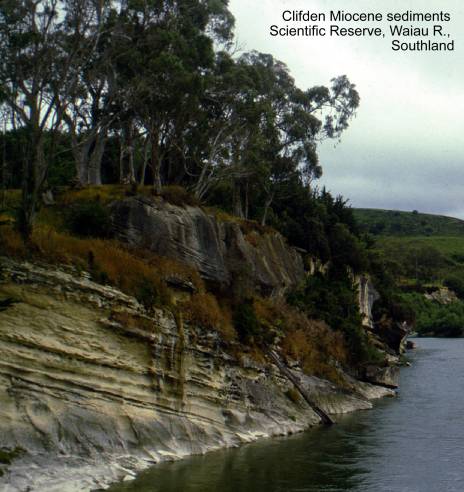
Abyss
Creek Triassic fauna. Map: D45; Classification: B3. Significance: Together
with Coal Creek, only richly fossiliferous early
Triassic in
Ackers stone house,
Alpine Fault, Hokuri Creek. Map: D39; Classification: C3.
Significance: Excellent exposures and traces of Alpine Fault, with good stratigraphuic and topographic control.
Alpine Fault,
Anchorage Cove Springs.
Map: C41; Classification: C2. Significance:
Aurora Cave (= Te Ana au), Lake Te Anau. Map: D42;
Classification: A3. Significance: Large, internationally important cave system
with its development related to Pleistocene glaciations. Contains
significant sedimentary deposits. The resurgence cave is a tourist
attraction.
Bald Cone exfoliation dome,
Balloon
Bare Hill zeolitised tuff zone, Hokonui
Hills. Map: E45; Classification: A3. Significance: Section through heulandite and analcime-bearing
Late Triassic tuffs in the Southland Syncline; a world class example of zeolite facies burial metamorphism.
Barracouta Point gabbro. Map: E47; Classification: C3. Significance:
Spectacular exposures of layered gabbroic rocks.
Beaumont Stream and quarry Triassic fossils.
Map: D45; Classification: B3. Significance: Endemic, in-situ Etalian fauna with ammonites used in international
correlation (quarry). Also holostratotype
of Etalian Stage in stream section.
Ben Bolt Jurassic fossils.
Map: E45; Classification: B3. Significance: Richest and most diverse Aratauran (Jurassic) fossil fauna in
Big Bay dune sequence and Waiuna Lagoon, northern Fiordland.
Map: D39; Classification: C3. Significance: The most
comprehensive dune sequence in northern Fiordland,
similar to those in
Big
Birch's Mill Pliocene shellbed. Map: C46; Classification: B3.
Significance: Very diverse macrofauna. Only good Pliocene fauna in southern
Blue Cliff Miocene fossils,
Te Waewae Bay. Map: C46; Classification: C3.
Significance: Moderately diverse Kapitean fauna.
Bluff and Tiwai
Point hornfels. Map: E47; Classification: B3.
Significance: Well-exposed hornfelses associated with
norite intrusion.
Bluff double estuary coastal features. Map:
E47; Classification: B2. Significance: Largest estuaries and spit on the South
Island’s south coast, with excellent examples of coastal features
including flood-tidal deltas, tombolo, wetlands and
one of the most extensive series of beach ridges in the country.
Browne Falls, Doubtful Sound. Map: D43;
Classification: B3. Significance: Highest cascading waterfall in
Braida Crags
limestone bluffs, Feldwick. Map: D45; Classification:
C2. Significance: Best example of limestone bluff (occasionally fluted) in
western Southland, easily visible from
Brydone Oligocene molluscan fossils. Map:
F46; Classification: B3. Significance: Very diverse Oligocene (Waitakian) molluscan fossils.
Caroline cutting Triassic
fossils. Map: E44; Classification: B3. Significance: Rich and diverse
Triassic (Kaihikuan) brachiopods and bivalves. Historically important type locality for brachiopod species
described by Trechman.
Castle Rock karst, Dipton. Map: E44;
Classification: B2. Significance: Best karstic
limestone bluff in Southland. Spectacular limestone ridgeline with most impressive development of
castle-like ramparts in Tertiary limestone in
Cleddau Chasm. Map:
D40; Classification: B3. Significance: A well defined and easily accessible
gorge.
Clifden limestone
bluffs. Map: D45; Classification: C2. Significance: Best, easily accessible karst features in Southland and one of the most diverse karstic landscapes in southern half of the
Clifden Miocene sediments. Map: D45; Classification: A3.
Significance: The 'classic' highly fossiliferous
reference section for middle Miocene sedimentary sequence in the
Coal Creek Triassic fossils.
Map: D45; Classification: B3. Significance: One of only two, richly fossiliferous early Triassic sites in
Conical Hill Jurassic
brachiopod fossils. Map: E45; Classification: B3. Significance: Diverse
lower Ururoan (Jurassic) brachiopod fauna. Type locality of several taxa.
Cow and Calf Point gabbro intrusion,
Croydon clinker. Map: F45; Classification: C2. Significance:
Representative example of thermally metamorphosed sediments associated with
naturally burnt coal in Southland.
Donne Glacier roche moutonnee and glacierised surfaces.
Map: D40; Classification: C3. Significance: Examples of roche
moutonnee and glacierised
surfaces which are undisturbed by NZ standards.
Doubtful Sound fiord.
Map: B43; Classification: B3. Significance: Deepest and second longest fiord in
Doubtful Sound gneisses.
Map: B43; Classification: B3. Significance: Well-exposed high grade gneisses of
both sedimentary and igneous origin.
Doubtful
Dusky Sound fiord.
Map: B44; Classification: B3. Significance: Longest and one of the most complex
fiords in
Dusky Sound zincian staurolite. Map:
B44; Classification: B3. Significance: Occurrence of the mineral staurolite, here having the highest zinc content in a zincian staurolite recorded
anywhere in the world. Here it is associated with other rare minerals.
Earl Mountains Cenozoic
sequence. Map: D41; Classification: C3. Significance: Complete sequence
through lower half of Te Anau Basin Cenozoic
succession. Type section for Earl Mountains Sandstone. Spectacular scarp
exposures along crest of range.
Ernest Islands tombolo. Map: D49; Classification: B3. Significance: A
particularly good example of a tombolo.
Eglinton River delta, Lake Te Anau. Map: D42;
Classification: B3. Significance: An actively prograding
river delta in a lake, a good example with easy access.
Fiordland fiords. Map: A44,
A45, B41-B46, C40-C43, D40; Classification: A3. Significance: Fiordland’s steep and crenulated coastline, with fiords running
from U-shaped glaciated valleys carved out of the
Forest Hill karst, Winton. Map: E46; Classification: C2.
Significance: Isolated limestone outcrops with spectacular solution
weathering. Small
pitfalls which contain common avifaunal fossils.
Freestone Hill limestone
bluff, Manapouri. Map: D43; Classification:
C2. Significance: Only karstic limestone in the Manapouri area. One
of the most impressive limestone bluffs in Southland.
Gair Loch debris dam. Map: C44; Classification: B3.
Significance: A good example of many such features in the district.
Gog and Magog exfoliation domes,
Goose-Woodhen
Isthmus,
Greenhills ventifacts, Bluff. Map: E47; Classification: B1.
Significance: Some of largest and best developed ventifacts
in
Green Islets wave-cut
notches. Map: B46; Classification: B3. Significance: A spectacular set
of wave-cut notches, caves and arches.
Haldane estuary. Map: F47; Classification: C3. Significance: A good
example representative of a Southland estuary.
Heale Ridge Jurassic fossils. Map: E45; Classification: B3.
Significance: Very rich, shallow marine bivalve and brachiopod fauna. Unique
Helmet Hill to Goldie Hill karst. Map: C46; Classification: B2. Significance:
Pristine active and fossil karstic landscape in
virgin forest, with potential for future discovery of major cave systems and
significant fossil avifauna.
Hidden
Hokonui Hills strike
ridges. Map: F45; Classification: B3. Significance: Some of
Homer Saddle glacial
features. Map: D40; Classification: B3. Significance: A collection of
well defined glacial features, the Homer Saddle being of particular historic
importance as the only direct inland crossing to Milford Sound.
Horseshoe Bay hornblende hornfels,
Stewart Island. Map: E48; Classification: C3. Significance: A good
representative example of hornblende hornfels.
Howells Point pillow lavas. Map: D46;
Classification: B3. Significance: Pillow lavas and pumpellyite
mineral location.
Humboldt Falls. Map: D40; Classification: B3.
Significance: Highest falls in
Iris Burn Slip, Kepler
Track. Map: C43; Classification: C3. Significance: Excellent example of a huge
recent rockfall from the steep side of a glacial
valley.
Kaherekoau aegirine. Map: C45;
Classification: C3. Significance: A good example of a mineral rare in
Kellard Point marble.
Map: B43; Classification: B3. Significance: Well-exposed marble in central Fiordland high-grade gneisses.
Kershaw to Coal Creeks ridge intrusion. Map:
D44; Classification: C3. Significance: Well exposed shallow gabbro
intrusion.
Key Summit Permian lower Maitai
Group meta-sediments and syncline. Map: D41; Classification: B2. Significance:
Best, easily accessible outcrops of lower Maitai
Group lawsonite-bearing, low temperaturepressure
slate. Includes an unusual occurrence of sodic-amphibole,
an indicator of high pressure, low temperature metamorphic condition. A good
exposure of a syncline of unique regional continuity.
Kisbee Bay
Ordovician biostratigraphic section. Map: B46;
Classification: B2. Significance: Important biostratigraphic
section through lower Ordovician graptolite-bearing rocks.
Knobs Flat kames. Map: D41; Classification:
C2. Significance:
Kowhai Creek Triassic fossils. Map: D44;
Classification: C3. Significance: Well-preserved Triassic (Kaihikuan)
macrofossil fauna.
Lake Adelaide rockfall.
Map: D40; Classification: B3. Significance:
Letham Ridge thrust
zone and melange. Map: D44; Classification: B3.
Significance: The best regional exposure of a terrane
boundary and one of the best examples of a mudstone melange
in
Luxmore Cave, Te Anau. Map: C43; Classification: C3. Significance:
Largest of Mt Luxmore caves, and best representative
example of these alpine caves.
MacLean Peak basalt and andesite
type section. Map: D44; Classification: C3. Significance: Type section of the
MacLean Peak Formation, basalt to andesite flows.
MacLean Peak pillow lava. Map: D44;
Classification: C3. Significance: Interesting features within a pillow lava
flow.
Mararoa River Permo-Triassic Maitai
Group sediments. Map: D43; Classification: C3. Significance: Excellent
exposure of Upukerora Breccia
and Waiau and Stephens Formations, Maitai Group.
Mavora Lakes vuagnatite. Map: D42; Classification: B3. Significance: Only
in situ occurrence of vuagnatite in
Milford Sound fiord.
Map: D40; Classification: B3. Significance: Best known and most accessible of
the breathtaking fiords in Fiordland.
Mokomoko Inlet Permian sedimentary rocks. Map: E47; Classification:
B3. Significance: Exceptionally well preserved Early Permian sea floor sedimentology and trace fossils.
Monkey Creek hanging valley.
Map: D41; Classification: C3. Significance: A well defined hanging valley.
Monowai Suspension
Bridge Oligocene flysch. Map: D44; Classification:
C4. Significance: A good exposure of mass flow breccia
and flysch for educational purposes.
Moonlight Fault backtilted
terrace. Map: D43; Classification: C3. Significance: Excellent example of post-glacial
backtilting of late Quaternary terrace surface.
Morley Bridge quarry Triassic macrofossils.
Map: D45; Classification: B3. Significance: Good Etalian
macrofauna.
Mossburn Permo-Triassic fossiliferous volcaniclastic sequence. Map: E44; Classification: B2.
Significance: Only example of Maitai Group rocks in
the region. Diverse late Permian fauna. Allochthonous
material in the exposure.
Mossburn serpentinite quarry. Map: E44; Classification: C2.
Significance: Excellent exposure of serpentinite melange.
Mt Anglem cirque and
tarns, Stewart Island. Map: D48; Classification: C3. Significance: Best and
most easily accessible, representative example of an old glacial cirque and
tarn on
Narrow Neck Isthmus, Fiordland.
Map: D43; Classification: C3. Significance: One of the narrowest and lowest
altitude isthmuses in Fiordland separating a region
as large as
North Mataura
Jurassic plant beds. Map: F45; Classification: B2. Significance: Rich
Jurassic plant fossil beds of historical importance because they were first
described by Arber, 1917. Type
locality for two species.
Oraka Point intrusions. Map: D46; Classification: C3.
Significance: Type location of Oraka Hybrids
containing basic xenoliths. Good coastal exposures. Remarkable
example of the assimilation of basic rocks by a high-level granitic
magma.
Orepuki oil shale pit. Map: D46; Classification: C3. Significance:
Only oil shale in
Oreti River (east)
Triassic fossils. Map: E44; Classification: B4. Significance: Rich fossil fauna
and lower part of the holostratotype of New Zealand Oretian Stage (Triassic).
Otamita Stream
Triassic fossils and stratotype. Map: F45;
Classification: B3. Significance: Stratotype of New
Zealand Otamitan Stage (Triassic). Very
well-preserved fossil material.
Otamita Valley Rd
sequence. Map: F45; Classification: B4. Significance: Stratigraphic
section through Taringatura Group, with well exposed sedimentological features at various horizons.
Otapiri Stream
Triassic stratotype. Map: E45; Classification: B3.
Significance: Holostratotype of Otapirian
Stage. Diverse fossil faunal assemblage. Type locality of endemic Otapirian fauna. Nationally important exposure of
Triassic-Jurassic boundary.
Pahia Point layered mafic rocks and shore platform potholes. Map: D46;
Classification: C3. Significance: Type location of Pahia
Intrusives. Well defined shore platforms with
excellent examples of potholes.
Paterson Inlet,
Pears Track Triassic
fossils. Map: D44; Classification: C3. Significance: Good Triassic
(early Oretian) macrofauna.
Pembroke granulite.
Map: D40; Classification: A3. Significance: First described and probably best
developed planar alteration zones in granulite,
world-wide.
Pikopiko fossil
forest. Map: D45; Classification: A2. Significance: Best example of an Eocene
fossil forest in New Zealand. One of few fossil plant loacalities
in the world having ferns with fertile sporangia and more than 3 kinds of fern
leaf.
Port Craig Tertiary sequence. Map: C46;
Classification: C3. Significance: Magnificent example of submarine turbidites (Oligocene) overlain unconformably
by a nearshore bioclastic limestonebreccia sequence (Pliocene). Regionally
significant unconformity of Late Miocene age, reflecting progressive uplift of
Hump Ridge horst during Middle Micoene. Includes the only diverse Kapitean (Late
Miocene) fauna in the southern
Port Pegasus, Stewart Island. Map: D49; Classification:
B3. Significance:
One of
Port William dikes,
Potters Graben. Map:
F43; Classification: C2. Significance: One of the best examples of quartzose 'cover' sediments preserved on the uplifted peneplain of Central Otago.
Preservation Inlet hornfels.
Map: B45; Classification: C3. Significance: Well-exposed example of horfelses and contact schists.
Productus Creek laumontite. Map: D44; Classification: B3. Significance: An
unusually well developed example of replacement of fossils by laumontite - one of the best examples in New Zealand.
Productus Creek
Permian fossils, Letham Burn. Map: D44;
Classification: B3. Significance: Holostratotype of Braxtonian Stage.
Productus Creek
Permian fossils, Mangarewa locality. Map: D44;
Classification: A2. Significance: Rich, well-preserved brachiopod and molluscan fauna. Only New Zealand occurrence of
Glossopteris leaf fossils.
Productus Creek
Permian Wairaki Breccia
localities (Letham Trig). Map: D44; Classification:
A3. Significance: Youngest Permian fauna from New Zealand. Holostratotype
of Makarewan Stage, Wairaki
Breccia.
Redcliff Creek
section, Takitimu Mountains. Map: D44;
Classification: C3. Significance: Type section of the Brunel
Formation, volcaniclastic sediments and basaltic lava
flows.
Ringaringa intrusives, Stewart Island. Map: E48; Classification: B3.
Significance: Excellent, well exposed outcrops of hybrid and composite rocks
developed between hornfels and acid intrusive rocks.
Routeburn Falls
glacial stairway. Map: D40; Classification: B3. Significance: One of the two
best examples of a glacial stairway in
Rugged Point coastal
features,
Ruggedy Flats
freshwater valley,
Shell Gully Oligocene fossils. Map: F45;
Classification: B2. Significance: Diverse, well-preserved Oligocene (Duntroonian) fossil molluscs.
Smoky Beach climbing dunes. Map: D48;
Classification: C3. Significance: The
most northern of
St Anne Point gneiss.
Map: D40; Classification: C3. Significance: Excellent example of well exposed quartzo-feldspathic, garnetiferous
gneiss, locally with marble or calc-gneiss.
Sutherland Sound fiord.
Map: C40; Classification: C3. Significance: Unusual fiord landform because it
does not open directly to the sea; it is only connected to the sea by a tidal
river.
Takitimu epistilbite. Map: D44;
Classification: B3. Significance: Good exposure of the mineral epistilbite, which is regionally developed in the eastern
Takitimu yugawaralite. Map: D43; Classification: B3. Significance:
The only New Zealand occurrence of yugawaralite.
Taringatura Hills
Triassic locality. Map: E44; Classification: B3. Significance: Only fossiliferous Otapirian in
southern
Te Anau erratic boulder. Map: D43; Classification: C1. Significance: An
isolated 3 m erratic boulder sitting on the flat outwash surface beside the
road providing evidence of a former extensive glacier about 100,000 years BP.
Interpreted to be a lag deposit from a moraine related to an extensive glacier.
Te Anau
South Fiord sedimentary sequence. Map: D43; Classification: C3.
Significance: Well exposed Oligocene-Miocene sequence typical of the west
margin of Te Anau Basin, with excellent cross-bedding
and cyclic sedimentation.
Three Sisters steep dunes, Bluff. Map: D40;
Classification: C2. Significance: An example of how wind-blown sand can
transgress steep topography in southern
The Neck multiple tombolos,
Upukerora authigenic minerals. Map: D42; Classification: B3.
Significance: A rare occurrence of authigenic low
temperature minerals replacing the matrix of a Quaternary landslide deposit.
Waiau Cave, Clifden. Map: D45; Classification: C1. Significance:
Isolated lowland cave.
Waiau River Miocene deep-water fossils. Map: D44; Classification:
C3. Significance: Well-preserved, diverse, bathyal,
middle Miocene (Waiauan) fossil macrofauna.
Waiau River
Oligocene sandstone dikes. Map: D44; Classification: B2. Significance: One of
the best examples of sand injection structures developed during large scale
folding in New Zealand Tertiary rocks.
Wairaki Hills
Triassic fossiliferous volcaniclastics.
Map: D44; Classification: C3. Significance: The most fossiliferous
and diverse early middle Triassic locality in New Zealand.
Wairaki Peaks rhyodacitic tuff. Map: D44; Classification: C3.
Significance: Good example of a Permian rhyodacitic Plinian-style tuff.
Wairaki Peaks,
Heartbreak Formation igneous section. Map: D44; Classification: C3.
Significance: Type section of the Heartbreak Formation, microgabbro
and basaltic lavas, pillow lava and breccia.
Wairaki River fault trace. Map: D44; Classification: C3. Significance:
Excellent regional example of a Late Quaternary fault scarp.
Wairaki River Permain fossils. Map: D44; Classification:
B4. Significance:
Holostratotype of Telfordian
and Mangapirian Stages.
Waituna coastal lake lagoon and wetlands. Map: F47; Classification:
B2. Significance: The classic example in
Waituna Miocene lignite pit. Map: F47; Classification:
C3. Significance:
Lignite pit, type locality for pollen species.
Wendon Valley Oligocene fossil molluscs.
Map: F44; Classification: B3. Significance: Very diverse fossil Oligocene (Duntroonian) molluscs.
West Plains igneous basement. Map: E46;
Classification: C1. Significance: Only exposure of ?BluffGreenhills
Igneous Complex in extensive West Plains area. important for understanding
geology of the region.
Wether Hill zeolite metamorphism. Map: E44; Classification: A3.
Significance: Internationally classic example of zeolite
facxies metamorphism.
White Hill zeolite
metamorphism. Map: E44; Classification: A3. Significance: Internationally
classic example of zeolite facies
metamorphism.
Winton Hills tomo. Map: E46; Classification: C2. Significance: Best
examples in an extensive area along a ridgeline of small dolines
and pitfalls, otherwise rare in Southland. Contain common avifaunal fossils.