Northland
Region 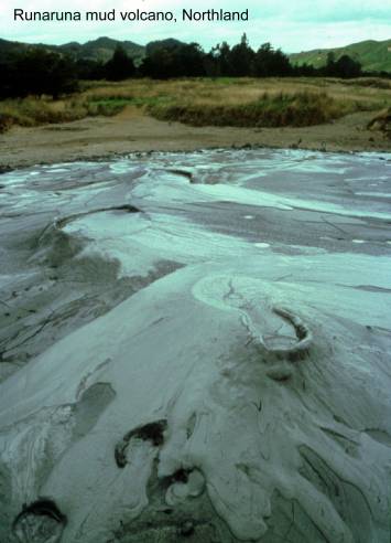
Ahipara gumfield relics. Map: N05; Classification:
B2. Significance: The best preserved area of remains relating to kauri gum
digging and processing.
Ahipara Pliocene lignite. Map: N05; Classification: C2. Significance:
Oldest dated sand dunes in Far North.
Ahipara Tangihuas basal melange. Map:
N05; Classification: B3. Significance: Basal melange
of the Tangihua obducted ophiolites.
Aorangi Island terraces. Map: R06; Classification: C3. Significance: Well
preserved sequence of 8 uplifted marine terraces reaching 170-185 m (700000
years?). Locally derived rounded pebbles on terraces (the most well rounded
occurring on highest terrace) in contrast with present day sea cliffed coast. Terrace surfaces modified by prehistoric
Maori horticulture.
Arrow Rocks. Map: P04; Classification: B3.
Significance: One of few exposures of the Permian-Triassic boundary in the
Southern Hemisphere.
Avoca karst.
Map: P07; Classification: C2. Significance: Most easily accessible and visible
blocks of crystalline Whangarei limestone in the allochthon. Crystalline limestone is rare in the allochthon.
Avoca trace fossils. Map: P07; Classification: B1. Significance: One
of best bedding plane exposures of well-preserved three-dimensional Scolicia trace fossils in
Black Rocks columnar basalt,
Bream Head stratovolcano. Map: R07; Classification: C3. Significance:
Best exposed section through the cone facies and
underlying subvolcanic intrusions in the Taurikura centre around Whangarei
Heads.
Bushy Point clinoptilolite.
Map: Q09; Classification: C2. Significance: A rare example of clinoptilolite replacing fossil shells.
Cave Stream sediments,
Cone Rock, Far North. Map: P04;
Classification: C3. Significance: Spectacular
conical pinnacle. Well known landmark for boaties.
Coral Point, Hukatere Miocene mass flow deposits. Map: Q08;
Classification: C3. Significance: Well exposed fossiliferous
mass flow deposits, where the differing biotas
demonstrate different provenances.
Crows Nest Quarry melange.
Map: Q06; Classification: C2. Significance: One of the best exposures of
sheared melange at the base of the Northland Allochthon.
Glenbervie (Maruata) volcanic cones. Map: Q06;
Classification: C2. Significance: A well preserved young volcanic centre
with two scoria cones.
Hewlett Point karst,
Hikurangi dome. Map: Q06; Classification: C3. Significance: Prominant volcanic landform, one of two young dacite domes north of Whangarei.
Hikurangi Quarry
basal allochthon. Map: Q06; Classification: B4.
Significance: Northland Allochthon exposed overlying
in situ Whangarei Limestone. One of the best and most
accessible sites in Northland to demonstrate the allochthon
contact.
Hikurangi Shaft coalmine
relics. Map: Q06; Classification: C2. Significance: Last working coalmine in Hikurangi. Possibly the only coalmine in Northland to be
worked from a shaft.
Hokianga Miocene
"Orbitolite" bed. Map: O06; Classification:
C2. Significance: Discovered by Hochstetter in 1860s.
Predominantly composed of larger foraminifera of international biostratigraphic value. Contains largest
known foraminifera in
Hokianga sand dunes. Map: O06; Classification: B1. Significance: A
large area of active sand dunes reaching heights of 200 m.
Hoods Road Quarry thomsonite
and apophyllite. Map: O07; Classification: C4.
Significance: One of the region's best and most accessible localities for thomsonite and apophyllite.
Houto spilite. Map: P07; Classification: C3. Significance: Oldest
known occurence of allochthonous
ophiolites (Tangihuas) in
Northland.
Huruiki basalt and rhyolite (obsidian). Map: Q06; Classification: C3.
Significance: An obsidian locality of archeological significance, once used by
the prehistoric Maori. The Kerikeri VolcanicsPutahi Rhyolite contact
is exposed.
Hurupaki
scoria cone. Map: Q06; Classification: C1. Significance: One of three
scientifically interesting scoria cones. A quarry exposes an eruption sequence
showing that magma variation occurred during eruption. The best such exposure
in a young Whangarei centre.
Jellicoe Cave. Map:
P04; Classification: C3. Significance: Unusual narrow (1-2 m wide) navigable
(small dinghy) sea cave that passes right through small point. Linked
historically to Lord Jellicoe who holidayed there.
Kaiaraara
Island top hat islet, Russell. Map: Q05; Classification: A2. Significance: First “old hat” islet in the world to be
described (Dana 1849) and used as the classic example by Bartrum
(1916, 1924, 1925) to describe the “old hat” phenomenon in New
Zealand and world-wide.
Kaiikanui
basaltic proto-karst, Helena Bay. Map: P07;
Classification: B2. Significance: One of
2 best examples in the Helena Bay area of fluted surfaces (karstose)
formed on basalt (the other example being on the Russell Road at Stoney Knowe).
Kai Iwi dune dammed
lakes. Map: O07; Classification: B3. Significance: Several large dune dammed
lakes, including the two deepest dune lakes in New Zealand, Lake Taharoa at 37 m and Lake Waikeri
at 30 m. None have any surface inlet or outlet.
Kaikohe scoria cone.
Map: P05; Classification: C2. Significance: A small breached scoria cone.
Kaimaumau Swamp and
sand dunes, Houhora. Map: O04; Classification: C2.
Significance: One of the largest and
least modified, less developed areas of longitudinal, parabolic and transverse
sand dunes in Northland.
Kamo Hot Springs.
Map: Q06; Classification: C2. Significance:
Kamo limestone
pinnacles. Map: Q06; Classification: C1. Significance: Best preserved limestone karst
pinnacles in Northland. In small area close to Whangarei
city, already protected in private reserve with bush remnants and QE2 covenant.
Some of deepest and sharpest fluting on a limestone in NZ.
Kamo No.3 coalmine
relics. Map: Q06; Classification: C2. Significance: One of the largest
producing coalmines in Northland.
Kapowairua
prehistoric adze workings. Map: N02; Classification: B2. Significance: One of
the largest and best preserved prehistoric adze working sites in New Zealand.
Karaui Point dacite dome. Map: P04; Classification: C3. Significance: Good
exposures of small eroded flow-banded dacite dome.
Karikari hornfels. Map: O03; Classification: C3. Significance:
Reasonably well-exposed hornfels locality.
Karikari
Peninsula tombolo dune fields. Map: O04;
Classification: B2. Significance: An
extremely large tombolo containing some of the most
outstanding examples of coast-parallel foredunes in
Northland.
Kauri Mountain hornfels
and metallic mineralisation. Map: R07;
Classification: B3. Significance: Well-exposed example of hornfels.
Veins of meatllic mineralisation
including galena, sphalerite and pyrite.
Kawerau lava flow
reefs, Waipoua coast. Map: O06; Classification: C2.
Significance: Prominent point on exposed
west coast, formed by west-dipping sequence of basalt lava flows, producing the
seaward tilt of some large reefs.
Kawiti scoria cone
and Moerewa lava flow. Map: P05; Classification: C1.
Significance: Scoria cone with a lava flow following the Kawakawa Valley.
Kerikeri stone
store. Map: P05; Classification: B2. Significance: Oldest stone building in New
Zealand.
Koutu giant
concretions, Hokianga. Map: O06; Classification: B1.
Significance: Largest concretions in
Northland. Some of largest and most accessible spherical concretions that have
been eroded out of their host rocks in New Zealand.
Lake Manuwai karstic basalt, Kerikeri. Map:
P04; Classification: A1. Significance: Most
spectacular example of a fluted basaltic boulder field in NZ.
Lake Ohia gumdigging holes. Map: O04; Classification: B1.
Significance: One of the best preserved groups of gumdiggers
holes left in NZ. Easy access.
Lake Ohia
Pleistocene fossil forest. Map: O04; Classification: C2. Significance: Well
preserved and now partly exhumed buried Quaternary kauri forest. 30,000 years
old.
Lake Ohia Quarry
pyrite. Map: O04; Classification: C2. Significance: Excellent specimens of
pyrite nodules in shale.
Lake Omapere. Map:
P05; Classification: B3. Significance: Lake formed by a lava flow damming
valley.
Lodore Road obsidian
source. Map: P05; Classification: C3. Significance: Source of unique dacitic obsidian utilised in
prehistoric times.
Lower Puhipuhi Flats
basalt flows. Map: Q06; Classification: C3. Significance: A basalt plateau
formed from ponded lava, overlying greywacke.
Mahinepua Peninsula,
Whangaroa Bay. Map: P04; Classification: C3.
Significance: Unusual long, narrow
greywacke peninsula on east coast of Northland, probably resulting from
protection from marine erosion by the band of basalt of Flat Island off the
seaward end.
Manaia stratovolcano breccia pinnacles.
Map: Q07; Classification: B3. Significance: Most prominent exposures of Miocene
volcanic breccia and the best of two areas of ridge
top tors in the Whangarei
Heads area.
Mangaru Range pillow lava - hyaloclastite sequence. Map:
P07; Classification: B2. Significance: Best exposures of pillow lava and hyaloclastite in upper part of Tangihua
Complex sequence.
Mangawhai spit. Map:
R08; Classification: B2. Significance: One of the best examples of a sand dune
barrier spit in the Auckland City region. Only known sand dune system to
preserve a distinctive volcanic ash horizon (Kaharoa Tephra) within its stratigraphy
that allows its recent dynamic history since human arrival to be documented.
Mangonui
barrier-enclosed estuary. Map: O04; Classification: C3. Significance: Classic
example of a rare tombolo barrier-enclosed estuary.
Mangonui Miocene
coconut beds. Map: O04; Classification: B2. Significance: Best preserved fossil
coconuts in
Marble Bay Permian fusulines, corals, spilite and melange. Map: P04; Classification: A3. Significance:
Of national importance in paleogeographic
reconstructions. Important association of pillow lava with Permian Tethyan facies and melange. Best of only a handful of
Permian localities in the
Maungakaramea scoria cone. Map: Q07; Classification: C1. Significance: A
well preserved scoria cone with a distinct form that has not been quarried. The
southernmost Quaternary Volcanic centre in Northland.
Maungakawakawa
scoria cone. Map: P05; Classification: C2. Significance: A very good example of
breached scoria cone, breaching clearly as a result of 'rafting' during cone
formation.
Maunganui Bluff
basalt. Map: O07; Classification: B3. Significance: Best exposure of Waipoua Basalt.
MaungapareruaWaimate
North weathered rhyolite. Map: P05; Classification:
C3. Significance: Weathered rhyolite material.
Maungaraho dike with
mineral harmotome, Tokatoka.
Map: P08; Classification: B2. Significance: Largest dike in Tokatoka
area. Forms a prominant ridge (200 m high) of the
resistant dike surrounded by erosioned softer
sedimentary rocks. Very good example of the unusual mineral harmotome.
Maungaraho intrusive
volcanic breccia. Map: P08; Classification: C2.
Significance: Well exposed example of early Miocene volcanic breccia intruding Mahurangi
Limestone.
Maungatapere
volcanic cone. Map: Q07; Classification: B2. Significance: An almost perfect,
steep sided volcanic cone, not farmed or quarried. Largest and best preserved
in Whangarei field.
Maungaturoto
volcanic cone. Map: P05; Classification: C2. Significance: Well preserved
volcanic form typical of the younger centres in
Northland.
Maunu volcanic cone. Map: Q07; Classification: C1. Significance: A
relatively well preserved cone near Whangarei, which
has been modified a little by farming, minor quarrying and roading.
Mititai breccia-filled volcanic neck, Tokatoka. Map: P08; Classification: C2.
Significance: Best exposed of several breccia-filled
necks in the Tokatoka area.
Motukawanui pillow lava,
Motukokako (Piercy)
Motukokako (Piercy)
Mt Camel terrane
volcaniclastics. Map: N03; Classification: C3.
Significance: Demonstration of contemporaneity of
Mount Camel Volcanics and associated flysch.
Ngahuha scoria cone. Map: P05; Classification: C2. Significance: A
scoria cone and flow which follows the
Ngararatunua volcanic cone. Map: Q06; Classification: C1.
Significance:
Distinct scoria cone breached to south.
Ngawha Springs
hydrothermal field. Map: P05; Classification: B2. Significance: A geothermal
area with cinnabar. Hydrothermal area with current deposition. Mined for
mercury as a strategic mineral.
Ngunguru
barrier-enclosed estuary. Map: Q06; Classification: C3. Significance: One of
the most accessible and least populated estuaries on the east coast of
Ngunguru sandspit. Map: Q06; Classification: C2. Significance: The
only undeveloped sandspit remaining in the Northland
region. Potentially useful for research
into short- to medium-term coastal geomorphological
processes, post-Last Glacial Maximum transgression, provenance and sand
distribution patterns, catchment-to-sea analysis of
the sedimentological history of a small Northland
system, and sea-level studies.
Ninepin sea pinnacle,
Ohia black shale.
Map: O04; Classification: B2. Significance: Best exposure of black shale in
Northland; one of best in
Okaihau basalt plateau. Map: P05; Classification: C3. Significance: An
elongate lava plateau.
One Tree Point interglacial beach and dune
deposits. Map: Q07; Classification: B1. Significance: Well exposed Late
Pleistocene regressive coastal sand sequence with spectacular intertidal trace fossils. Only remaining exposures in the
area that are not obscured by coastal foreshore protection works, and should be
left in their unmodified state.
One Tree Point relict dunes
and beach ridges,
Onemama Point allochthonous sediments,
Onerahi overturned
syncline. Map: Q07; Classification: C3. Significance: Well exposed example of
weakly deformed block within the Northland Allochthon.
Onoke scoria cone
and ballast pit: O06; Classification: C2. Significance: Visually prominent,
bush-clad peak of scoria cone is valuable part of Kamo's
landscape and one of the volcanoes of the Whangarei
basalt field. Overgrown remains of railway ballast quarry and its associated
earthworks is best example of this kind of industrial site in a scoria cone in
Opononi limestone, Hokianga. Map: O06;
Classification: C3. Significance: The best exposure in the Hokianga
area of a small sequence through deep water Oligocene limestone with redeposited sandstone beds.
Otangaroa Caves, Mangamuka. Map: O04; Classification: C3.
Significance:
Fossil bone deposits, moa bones, site of discovery of extinct giant skink.
Otueka Hill Miocene fossiliferous sequence. Map: O05; Classification: C4.
Significance: Thickest, easily accessible sequence through Otaua
Group and also the most northerly. Contains diverse, redeposited,
shallow water fauna including reef corals and especially significant for the
barnacle plates of Lepas.
Pakaurangi-Puketi shelf sediments and fossils. Map: Q08; Classification: B2.
Significance: Most complete sequence through Hukatere
Subgroup, and richest fossil locality in
Pandora pillow lava.
Map: N02; Classification: B2. Significance: The best preserved and exposed
example of Tangihua Complex pillow basalt with
siliceous and micritic mudstone.
Paradise Quarry karst,
Parakao malachite, azurite and cuprite.
Map: P07; Classification: C3. Significance: Good examples of the copper
minerals malachite, azurite and cuprite.
Parakiore dome. Map: Q06; Classification: C3. Significance: Prominant volcanic landform, one of two young dacite domes in Whangarei area.
Paranui Falls. Map: Q06; Classification: C3. Significance: One
of five most scenic waterfalls over basalt flows in Northland.
Parengarenga - Te Pokere Miocene fossils. Map: N02; Classification: B3.
Significance: Diverse, warm-water molluscan fauna
(see Parengarenga record).
Parengarenga silica
sand. Map: N02; Classification: B3. Significance: A sand barrier spit being the
largest unvegetated spit in
Parengarenga-Paratoetoe Miocene sequence. Map: N02; Classification: B3.
Significance: Best exposed sequence through most of the upper Parengarenga Group: Type Paratoetoe
Formation. Diverse, warm water molluscan fauna (see Parengarenga record).
Perforated Point overturned fold. Map: N03;
Classification: C3. Significance: A good example of the deformation within the
Pompallier House,
Russell. Map: Q05; Classification: B3. Significance: The best example of
nineteenth century pise de terre
construction in
Poor Knights sea
arches and caves. Map: R06; Classification: B3. Significance: Best developed
marine eroded (at present and lower sea levels) arches, tunnels and caves in
Pouerua (
Pouerua prehistoric stonework. Map: P05; Classification: B2.
Significance: Most extensive, intact prehistoric garden system, with associated
stonework, in
Pouto sand dunes. Map: Q09; Classification: B2. Significance: Excellent, least modified part of the North Kaipara Head active dunelands
system.
Puhipuhi cinnabar. Map: Q06; Classification: B3. Significance: An
example of cinnabar occurring in siliceous sinter.
Puhipuhi stibnite
(Mt Mitchell). Map: Q06; Classification: C2. Significance: Fossil hydrothermal
stibnite and cinnabar.
Pukekaroro Dome.
Map: Q08; Classification: C3. Significance: One of best preserved examples of
an early Miocene volcanic dome landform in
Pukepoto basalt cone. Map: Q06; Classification: C1. Significance: A
young centre with a breached multivented cone, which
shows good volcanic landform.
Puketotara erionite. Map: Q09; Classification: A3. Significance: The
most silica-poor erionite variety reported.
Puketotora Peninsula
Miocene sediments. Map: Q09; Classification: B3. Significance: Most complete
sequence through Waitemata Group and lower Waitakere Group in Kaipara
region.
Puketutu (Puketona) volcanic cones. Map:
P05; Classification: C2. Significance: A group of cones, now largely quarried.
Pungaere rhyolite dome and associated obsidians. Map: P05;
Classification: B3. Significance: One of two well preserved Quaternary rhyolite domes and the only centre with associated peralkaline obsidians.
Putahi rhyolite dome with associated halloysite.
Map: P05; Classification: B4. Significance: Easily accessable
rhyolite dome in contact with (overlying) a
Quaternary basalt flow. Distinct volcanic form. One of only two crystalline peralkaline rhyolite domes of
Quaternary age in Northland. Excellent halloysite
deposit.
Queen Victoria Rock,
Rangi Point giant concretions, Hokianga.
Map: O06; Classification: C1. Significance: Some of the most easily accessible large concretions in Northland.
Rangiahua
autochthonous sediments. Map: O05; Classification: B3. Significance: Most
complete and best exposed autochthonous middle Tertiary sequence beneath the allochthon in Northland.
Rangiahua karstic basalt, Okaihau. Map:
P05; Classification: C2. Significance: Scattered
huge basalt boulders up to 20 m across, with lapiez
weathered surfaces. Example of rare karstic development on young
basalt lava flows in the region.
Rangiahua sinkholes, Okaihau. Map: P05; Classification:
C2. Signifiance: Only good, easily
accessible example of karst in northern Northland.
Rawene Paleocene limestones. Map: O05;
Classification: C3. Significance: Best exposures of deep water Paleocene
limestone facies in Northland.
Rawhitiroa scoria
cone. Map: Q06; Classification: C1. Significance: One of three scientifically
interesting scoria cones.
Rehia hornfels with mineral larnite.
Map: P08; Classification: B3. Significance: Significant because the hornfels contain larnite, one of
12 world occurrences. Also rare occurrence of scawtite.
Reserve Point (The Nook) Eocene shelf
sediments and fossils. Map: Q07; Classification: C3. Significance: Record of
deepening shelf sequence deposited in situ in Late Eocene. Unusual
shallow-water fossils.
Reserve Point nephelinite
flow and garnet andesite. Map: Q07; Classification:
B2. Significance: Only known nephelinite flow in
northern
Runaruna mud
volcano. Map: O05; Classification: B1. Significance: Only active mud volcano in
Northland.
Sail Rock stack. Map: R08; Classification: C3.
Significance: An excellent example of a marine eroded stack.
Simpkin's Quarry herschelite. Map: P08; Classification: B2. Significance:
Skull Creek algal limestone.
Map: Q07; Classification: B1. Significance: One of best and thickest examples
of an algal (rhodolith) limestone in
Skull Creek-Mangawhati Point autochthonous sediments,
South Bream Tail arch dome and
columnar-jointed reefs. Map: R08; Classification: C3. Significance: Best exposed Miocene dacite
dome in Northland. Best and most extensive example of coastal columnar jointing
in dacite in
St Pauls
dome-shaped hill, Whangaroa. Map: P04;
Classification: C3. Significance: A prominant dome
shaped rocky hilltop visible from many parts of the Whangaroa
area.
Stoney Knowe basaltic proto-karst,
Sweetwater dune-dammed
lakes, Awanui. Map: N04; Classification: C2.
Significance: Well-developed and easily
accessible longitudinal sand dunes with lakes and swamps in the intervening
swales.
Taipa garnet andesite
plugdike. Map: O04; Classification: C2. Significance: Only garnet-bearing
outcrop in Miocene Wairakau centre of Northland.
Takahiwai algal
limestone. Map: Q07; Classification: B1. Significance: One of the best examples
of algal (rhodolith) limestones
in
Tangowahine tidal
bore. Map: P07; Classification: B1. Significance: Only known tidal bore in
Tapotupotu estuary,
Tarahi scoria cone. Map:
P05; Classification: C2. Significance: A breached scoria cone thought to be the
highest centre in the Kaikohe area.
Taratara
butte. Map: P04; Classification: B3. Significance: A spectacular flat topped, steep
sided hill, the flat top controlled by very gently dipping strata. An unusual
feature in Northland.
Tauanui scoria cone,
lava flows and dammed lake. Map: P06; Classification: B2. Significance: One of
the best preserved volcanic cones in Kaikohe area with a distinct crater and
lava flows. One of three lakes in the Kaikohe area that have been formed by the
damming of a valley by the volcano andd its lava flows.
Tauranganui Stream mouth melange. Map: O04;
Classification: B3. Significance: An excellent example of a structural melange between nappes within the
Northland Allochthon.
Tawhiti Rahi prehistoric stonework. Map:
R06; Classification: B3. Significance: Best preserved stone wall defences around a prehistoric Pa in NZ.
Te Ahuahu volcanic cone. Map: P05; Classification: C2. Significance: A
well preserved volcanic cone. Basaltic bombs can be found in a small quarry at
this site.
Te Huka Beach and Kurahaupo Rocks Lower Miocene sediments. Map: N02;
Classification: C3. Significance: Best exposed sequence through most of lower Parengarenga Group.
Te Kopua Point, Hukatere Miocene volcaniclastics
and sedimentary structures. Map: Q08; Classification: B3. Significance: Well
exposed Puriri Formation within the top of the
Northland Allochthon. Volcaniclastic
sequence with good sedimentary structures, in deep marine environment.
Te Paki sand dunes. Map: M02; Classification: B1. Significance: Best
preserved area of active dunes on
Te Pene weathered rhyolite dome. Map: P04; Classification: C2. Significance:
Alkaline rhyolite with peralkaline
affinities thought to be part of Northland Quaternary Basalt association. Major
source of halloysitekaolin clay currently being
quarried and exported by NZ China Clays Limited.
Te Pua crater and
flows. Map: P05; Classification: C3. Significance: Volcanic form is still
evident but composition makes this centre important - it is not an "andesite" as was previously thought. Its stratigraphic position and relationship to other Kerikeri volcanic centres is
still under dispute.
Te Puke scoria cones. Map: P05; Classification: C2. Significance:
Three well preserved scoria cones and craters in a non-residential area of the
Te Reinga Bay thrust
contact. Map: O04; Classification: B3. Significance: One of the best examples
of contacts between nappes within the Northland Allochthon.
Te Rewa Pt Pleistocene fossils. Map: O06; Classification: B1.
Significance: One of the two richest Pleistocne
shallow marine fossil beds in Northland.
Te Ruatahi dune sequence. Map: Q06; Classification: C1. Significance: Rich
Holocene terrestrial fossil faunas
Te Werahi sand dunes and fossil fauna. Map: M02;
Classification: B1. Significance: One of best remaining examples of a
rapidly disappearing coastal landform. Rich fossil faunal remains.
Te Whau basalt lava
flow. Map: P04; Classification: C3. Significance: A large basalt lava flow.
Three Kings marine caves and arches. Map: L01;
Classification: C3. Significance: One of the three best examples of marine
eroded arches and caves around the coast of
Three Kings spilitekeratophyre sequence. Map: L01;
Classification: B3. Significance: Best exposed sequence of interfingering
spilite and keratophyre in
northern
Tikitikioure psilomelane and pyrolusite.
Map: Q05; Classification: C3. Significance: Good exposures of unusual minerals.
Titoki natural
bridge. Map: P07; Classification: B2. Significance: Best natural bridge formed
in lava in
Todds Quarry nephelinite. Map: P08;
Classification: C2. Significance: Best known of several middle Miocene nephelinite intrusions in Northland.
Tohumoana basalt
outliers. Map: Q06; Classification: C3. Significance: Basalt outliers with
cumulate olivine that may be mantle derived.
Tokatoka andesite plug. Map: P08; Classification: B2. Significance:
A prominant conical peak, 180 m high, formed by
resistant volcanic plug and erosion of softer surrounding rocks. Largest and best
exposed of numerous Miocene plugs in the Tokatoka
area..
Tokatoka thermal
metamorphism with kilchoanite and rankinite.
Map: P08; Classification: B3. Significance: Example of high temperature thermal
metamorphism and assimilation at a basalt-limestone contact. One of the three
known localities of kilchoanite and rankinite.
Two
Waikari Inlet "old hat". Map: Q05; Classification: B3.
Significance: A small island surrounded by broad intertidal
rock platforms, giving it the classic "old hat" shape. The best example of an "old hat" island in
Waikiekie karst. Map: Q07; Classification: C2. Significance: Most
accessible example of rare solution runnels developed in allochthonous
Oligocene Mahurangi Limestone. Karst
is extremely rare in the Northland Allochthon and Mahurangi Limestone is usually too argillaceous to develop karst features.
Waikuku tombolo dunes and dune-dammed swamp.
Map: N02; Classification: B1. Significance: One of best remaining areas of natural sand dune fields and dune-dammed
swamps in
Waimamaku, Pinehill Stream Miocene fossil molluscs. Map: O06; Classification: B3.
Significance: Very diverse, early Miocene molluscs.
Waimamaku, Taita Stream Miocene fossil molluscs.
Map: O06; Classification: B3. Significance: Diverse, early Miocene molluscs.
Waimamaku, Waimamaku River Miocene fossil molluscs.
Map: O06; Classification: B3. Significance: Very diverse, early Miocene molluscs.
Waimamaku-2 drillsite.
Map: O06; Classification: C3. Significance: Site of Waimamaku
- 2 drill hole. The encountered stratigraphy marked a
major turning point in understanding Northland geology and the recognition of
the Northland Allochthon.
Waimimiti scoria
mounds. Map: P05; Classification: C2. Significance: One of two localities where
abundant large, 1-10 cm, gabbroic inclusions can be found.
Waiomio Caves. Map: P05; Classification: C2. Significance: Spectacular glow-worm caves
and unusual karstic limestone pinnacles. Well known tourist attraction.
Waipu Cove
Oligocene-Miocene sediments and karst features. Map:
Q08; Classification: C2. Significance: Shows clear relationship between Waitemata flysch, Te Kuiti Group limestone and basement. Only karstic sea cave in
Northland. Shows clear relationship between Waitemata
flysch, Te Kuiti Group
limestone and basement.
Wairakau estuary.
Map: P04; Classification: C3. Significance: Best example of a flooded deeply
incised valley (or small gorge) in Northland. Now partly infilled
by modern sediments forming a tidal estuary with steep rocky walls.
Wairere boulders,
Wairua Falls. Map:
P07; Classification: C2. Significance: One of the five largest waterfalls over
Quaternary basalt flows in Northland.
Wairua
River meanders. Map: Q06; Classification: C2. Significance: One of the best
examples in Northland of a meandering river.
Waitahora Lagoon,
Waitangi flow gabbroic inclusions. Map: P05;
Classification: B3. Significance: Best locality for gabbroic inclusions of
Quaternary age in Northland.
Waitapu Bay
Cretaceous unconformity, Whangaroa. Map: P04;
Classification: C3. Significance: Best exposure of several around Whangaroa, where late Cretaceous conglomerates and micaceous sandstone unconformably
overlies with sedimentary contact an irregular surface of early Cretaceous Tupou Formation.
Waiwhatawhata coast
Miocene sediments and basalt flows, Hokianga. Map:
O06; Classification: B2. Significance: Excellent
exposures of marine deltaic conglomerate and terrestrial volcaniclastic
sequence. Best Miocene sequence in Hokianga region.
Well exposed section through three Waipoua Basalt
flows that form spectacular SW-sloping reefs.
Waro coalmine
relics. Map: Q06; Classification: C2. Significance: Some of the best preserved
coalmining relics in Northland.
Waro karst. Map: Q06; Classification: C2. Significance:
Excellent example of karst pinnacles close to
highway.
Wekaweka natural gas
seep. Map: O06; Classification: C3. Significance: Best, perhaps only, true
hydrocarbon seep in Northland.
Whakateterekia allochthon block. Map: O04; Classification: C3.
Significance: Basal block of allochthon, overturned,
overlying a melange zone.
Whakateterekia
Stream Eocene sediments. Map: P05; Classification: B3. Significance: Type
section of Mangapa Mudstone, and possibly the
thickest in situ Eocene in Northland.
Whangape pillow basalt. Map: O05; Classification: C3. Significance:
Among the best exposed and preserved examples of pillow lavas in the Tangihua Volcanic Group of Northland.
Whangape Pleistocene fossils. Map: O05; Classification:
B1. Significance:
One of two richest shallow marine fossil faunas in Northland.
Whangarei Falls. Map: Q06; Classification: C3. Significance: This
is one of the few natural exposures of a flow sequence in the Whangarei area. Important as an easily accessible example
of a waterfall formed by a resistant lava flow.
Whangaroa exfoliation domes. Map: P04; Classification:
C3. Significance:
A spectacular area of rocky exfoliation domes and ridges that surrounds
Whangaroa Harbour lacustrine sequence. Map: P04;
Classification: C3. Significance: Best exposure of lacustrine
sediments in Wairakau Volcanics
sequence. Excellent soft sediment deformation structures. One
of the best exposures of penecontemporaneous slump
folding in lake sediments in
Whangaroa North Head
ring plain deposits. Map: P04; Classification: B3. Significance: Best exposures of Miocene ring plain breccia deposits in northern
Whatitiri shield
volcano. Map: Q07; Classification: B2. Significance: Only example of a large
(4.4 cubic km), almost concentric shield volcano with gentle slopes in
Northland. Best example in
Whatuwhiwhi Cretaceous sediments. Map: O03; Classification: C3.
Significance: Best and most complete Cretaceous sedimentary sequence in
Northland and possibly the only autochthonous Cretaceous outcropping.