Nelson Region 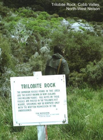
Abel Head fluviatile
sedimentary rocks. Map: M24;
Classification: C3. Significance: Well exposed coastal sequence of Paleocene to
Oligocene fluviatile sedimentary rocks. Only place to
see these extensive subsurface strata of
Aorangi Mine
first NZ graptolite discovery. Map: M25; Classification: B3.
Significance: Locality at which graptolites were first discovered in NZ by Cox
and Park and subsequently identified by Hutton in 1878 and published by Hector
in 1885.
Aorangi Mine Ordovician graptolites, Anthill Creek. Map:
M25; Classification: A2. Significance: Exceptionally well-preserved and
complete section through graptolitic lower Ordovician strata.
Aorangi Mine Ordovician graptolites, Slaty
Creek. Map: M25; Classification: A2. Significance: Only known section extending
through from lower to upper Ordovician with a full sequence of graptolites.
Aorere goldfields. Map: M25; Classification: B2.
Significance: First major goldfield in
Aorere Gorges.
Map: M25; Classification: C3. Significance: Easily accessible, deeply incised
gorges.
Aorere valley peneplain remnants. Map: M25; Classification: C3.
Significance: Best example of an exhumed peneplain in
Appleby Maori
"gravel borrow" pit. Map: N27;
Classification: C2. Significance: Only known remaining "borrow" pit
in the Waimea Plains area.
Arrow Rock (Fifeshire Rock). Map: O27; Classification: C3.
Significance: A highly visible and noteworthy sea stack in the natural entrance
to Nelson Haven.
Atawhai earthflow. Map: O27;
Classification: C2. Significance: An easily accessible and visible example of
an earthflow.
Bark Bay sand
barrier and estuary. Map: N26; Classification: C3. Significance: One of the
best examples in the region of a granite-derived coarse yellow sand beach, sand
barrier and sandy estuary.
Baton River-Moran Creek Paleozoic sediments. Map: M27;
Classification: C2. Significance: Only known exposure of unconformity at base
of Baton Group.
Bedstead Gully
chloritoid-staurolite schist. Map: M25;
Classification: B3. Significance: One of the best exposures of chloritoid schist in
Beebys
Conglomerate Cretaceous terrestrial sediments. Map: N29; Classification:
C4. Significance: Easily accessible and best exposed examples of late Mesozoic
terrestrial (fluviatile) sedimentation in this
region.
Bottom Rock
limestone lens,
Chaffeys Creek ridge Ordovician fossils,
Champion Creek hydrogrossular.
Map: O27; Classification: A3. Significance: Type locality of the mineral hydrogrossular.
Champion Mine copper and Smelter,
Cobb glacial valley. Map: M26; Classification: C3.
Significance: A large well defined glacial valley. The best
and most easily accessible in the northern
Cobb Valley Cambrian volcanics.
Map: M26; Classification: B3. Significance: Best exposed, fresh outcrops of
basic Cambrian Volcanics in Northwest Nelson.
Copperstain
Creek porphyry and skarn. Map: M25;
Classification: B2. Significance: Granodiorite
intrusion with copper mineralised skarn.
The best example in
Davis Creek gneiss. Map: M30; Classification: B3.
Significance: Good exposure of high grade garnetiferous
biotite gneiss containing sillimanite.
Delaware Inlet phyllonite. Map:
O27; Classification: A3. Significance: Good exposure of the Median Tectonic
Line boundary between two terranes.
Devils Boots,
Eastern Waimea Inlet islands and spits, Nelson. Map: N27;
Classification: C2. Significance: Least modified of many islands at the eastern
end of the largest enclosed estuary in the
Ed's Cellar cave, Takaka Hill.
Map: N26; Classification: C3. Significance: An unusual cave with deep vertical
shafts.
Eighty-Eight
Fault. Map: N28; Classification: C3. Significance: Excellent example of late
Quaternary displacement along the Eighty-Eight fault.
Eliot Creek
porphyry. Map: M25; Classification: C3. Significance: Best example and most
accessible of Cretaceous I-type porphyry Mo deposits in
Enner Glynn coal mine. Map: O27;
Classification: C5. Significance: One of the first coal mines in
Farewell Spit.
Map: N24; Classification: A3. Significance: An internationally significant,
actively growing Holocene sandspit complex; largest
in
Farewell Spit
tidal flats and channels. Map: N24; Classification: A3. Significance: Best
example of tidal flats and channels attached to a spit in
Glenroy buchite with clinoenstatite.
Map: M30; Classification: A3. Significance: An unusual occurrence of pyrometamorphism. The fourth terrestrial
occurrence of clinoenstatite.
Glenroy
granulites. Map: M30; Classification: C3. Significance: Good exposure of
the only granulites recognised west of the Alpine
Fault.
Gouland Downs karst.
Map: M26; Classification: C3. Significance: Spectacular karst
under full natural vegetation. Small caves, natural arches (track passes over
one) and surface solution features. A major scenic highlight
of Heaphy Track.
Graptolite Hill Ordovician fossils,
Haidinger
Bluffs. Map: M25; Classification: C3. Significance: Spectacular bluffs, prominantly viewed from
Hamama sinkholes, Takaka. Map: N26; Classification: C3. Significance:
Most concentrated and most representative easily accessible examples of
sinkholes within a 0.5km-wide belt of dolines
stretching 12km from Uruwhenua/Washaway Creek area to
west of Hamama, charting the phreatic
underground flow of the Arthur Marble - Takaka Limestone aquifer.
Heaphy Track hornfels. Map: M26; Classification: C3.
Significance: Unusual example of fresh andalusite and
cordierite in a contact aureole.
Hebberd's
prehistoric metasomatised argillite quarry,
HH Cave, Mt
Arthur. Map: M27; Classification: B3. Significance: Third deepest cave system
(1989) in
Hope Saddle glacial/interglacial sediments. Map: M28;
Classification: B3. Significance: One of best exposures of Moutere
Gravel sequences in the northern
Iron Ridge
Cambrian section,
Isel House, Stoke. Map: O27; Classification: C3.
Significance: Best of two known buildings made of Richmond Group greywacke.
Johnston's
United (formerly Perseverance) Gold Mine. Map: M25; Classification: C2.
Significance: First battery in the north of the South Island.
Kaihoka
dune-dammed lakes, Whanganui Inlet. Map: M24;
Classification: C3. Significance: Two of the best examples in Nelson of lakes
formed by sand dune dams.
Kairuru marble
quarry, Takaka Hill. Map: N26; Classification:
C3. Significance: Source of historic Kairuru Marble,
used on many important
Kaka clay mine. Map: M28; Classification: C3. Significance:
Possibly the only example of an underground clay (kaolin) mine.
Kaka lime kiln
and quarry. Map: M28; Classification: C1. Significance: A good example of a
kiln built to burn local limestone.
Labyrinth
Rocks karst, Takaka. Map: N26;
Classification: C2. Significance: Very accessible limestone public reserve
displaying features typical of a karst landscape.
Lake Otuhie dune-dammed lake. Map: M25; Classification: C3.
Significance: One of the best examples in the region of a lake dammed by sand
dunes.
Lake Stanley
debris dam. Map: M26; Classification: B3. Significance: One of the best
examples of a debris dam formed during the Murchison Earthquake, 1929. Resulted
in formation of Lake Stanley.
Lake Sylvester
cirque field. Map: M26; Classification: C2. Significance: A well developed
cirque field in a particularly scenic setting.
Ligar Bay quartz diorite. Map: N25; Classification: C3.
Significance: Well exposed quartz diorite containing xenoliths.
Ligar Bay tourmaline. Map: N25; Classification: B2.
Significance: Good tourmaline crystals to be seen in-situ.
Little Ben chromite. Map: N28; Classification: B3. Significance: The
best example of nodular chromite in New Zealand.
Little Ben
Sandstone. Map: N28; Classification: B3. Significance: Type locality of the
Little Ben Sandstone.
Lockett Range
limestone gendarme. Map: M26; Classification: C3. Significance: Gendarme of
Summit Limestone emplaced as a thin tectonic slice along Anatoki
Fault.
Magazine Point
Tertiary sediments and fossils. Map: O27; Classification: C3. Significance:
Good exposures, handy to schools showing many sedimentological
features, and minor structural features (faults) in Oligocene and Pliocene rocks.
Good section of marine sediment gravity flow deposits, storm redeposited sandstone and some debris flows. Site (The
Cliffs) of first recorded fossil find in New Zealand.
Maitai Valley lawsonite-bearing
rocks. Map: O27; Classification: B3. Significance: The first-described examples
of lawsonite-bearing metagreywacke
and marble in New Zealand.
Mangarakau Wetlands. Map: M25; Classification: C2.
Significance: Some of the largest freshwater wetlands in the northern
Marahau salt marsh. Map: N26; Classification: C2.
Significance: One of the largest and most accessible salt marshes in the Nelson area.
Marybank lawsonite-bearing rocks and plant fossils. Map: O27;
Classification: B3. Significance: One of the best examples of metamorphosed
siltstones with well-preserved plant fossils.
Matakitaki imbricate thrust sequence. Map: M30;
Classification: C3. Significance: Good example of an imbricate thrust sequence,
at a constraining bend of the Alpine Fault.
Meroiti doline field, Whanganui Inlet.
Map: M25; Classification: C3. Significance: Best example of rare doline development in extensive karst
landscape.
Meroiti
limestone pavement, Whanganui Inlet. Map: M25;
Classification: C3. Significance: Best example of limestone pavement development
on Tertiary limestone in
Motueka sandspit. Map: N27; Classification: B2.
Significance: Unusually shaped, multiply stranded sandspit.
One of the fastest-growing sandspits
in
Motupipi lime kiln. Map: N25; Classification: C1.
Significance: One of several, and best preserved, lime kilns in Golden Bay.
Motupipi
limestone hogback and karst, Takaka.
Map: N26; Classification: C3. Significance: Prominent ridge of Takaka Limestone, dragged up along Pikikiruna
Fault.
Moutere bluffs. Map: N27; Classification: C3. Significance:
A highly visible sea cliff readily seen from much of the Nelson coastal area.
Moutere Inlet barrier-enclosed
estuary, Motueka. Map: N27; Classification:
C2. Significance: A complex double-spit and barrier island-enclosed estuary.
Mt Arthur marble karst. Map: M27;
Classification: A3. Significance: One of the best areas of glacio-karst
in the southern Hemisphere.
Mt Arthur tablelands. Map: M27; Classification: B2.
Significance: The best
Mt Burnett dolomite. Map: M25; Classification: B2.
Significance: Only significant occurrence of dolomite in New Zealand.
Mt Burnett uvarovite and Zn-chromite. Map:
M25; Classification: B3. Significance: A good occurrence of an unusual mineral,
associated with the world's second highest Zn content in a chromite.
Mt Mytton early Paleozoic section. Map: M27; Classification:
B3. Significance: Unique section through late Cambrian to middle Ordovician
sequence. Part of the basis for New Zealand's national conodont
zones.
Mt Owen marble karst. Map: M28;
Classification: A3. Significance: One of the two best areas of glacio karst in the southern
Hemisphere (Williams, 1987).
Mt Owen,
Bulmer Caverns. Map: M28; Classification: A2. Significance:
Mt Patriarch limestone summit folding. Map: M28;
Classification: C3. Significance: A good example of deformation in calcareous
units of the Eastern Belt of NW Nelson.
Mt Patriarch
to John Reid Hut Paleozoic fossils. Map: M28; Classification: B3. Significance:
Unique section through upper Cambrian and lower Ordovician carbonate facies with excellent conodonts,
trilobites and molluscs.
Mt Snowden oolitic limestone. Map: M26; Classification: B3.
Significance: Only oolitic limestone formation in New
Zealand.
Nelson boulder
bank. Map: O27; Classification: A2. Significance: Best known boulder bank spit
in
Nelson Haven estuary. Map: O27; Classification: B2.
Significance: A prominent, easily accessible and highly visible estuary created
behind a boulder barrier spit.
Nguroa to Paturau limestone coastal features. Map: M24;
Classification: C3. Significance: Spectacular stretch of coastal features
eroded out of mostly Oligocene limestone.
NW Nelson
offshore faults. Map: ; Classification: C3. Significance: NW trending normal
faults associated with moderately tight folding of Tertiary (Landon-Paeora) sediments. Faults cross cut an inferred Pleistocene
shoreline area. Maximum apparent dip on anticline limbs c.15 degrees.
Onekaka Iron Works complex. Map: M25; Classification: B1.
Significance: Relics of only iron ore mining and processing operation in New
Zealand.
Owen Ice
Cavern. Map: M28; Classification: B3. Significance: Best known ice cave in
Parapara
hematite quarry. Map: M25; Classification: B3. Significance: One of New
Zealand's best exposures of iron-ore. A unique example of a hematite quarry for
paint in New Zealand. An early and significant supplier of paint (New Zealand
Hematite Paint Company).
Parapara Peak Permian fossils. Map: M25; Classification:
A3. Significance: Only fossiliferous Permian locality
in western (Tuhua) belt.
Parapara Quarry tourmaline. Map: M25; Classification: B2.
Significance: Brown and green tourmaline, rare in New Zealand.
Pariwhakaoho River kyanite. Map:
M25; Classification: B3. Significance: A good example of kyanite
in its natural setting in outcrop.
Paturau marine terraces. Map: M25; Classification: C3.
Significance: Best series of marine terraces in the Nelson region.
Paynes Ford stalactite bluffs, Takaka.
Map: N26; Classification: C1. Significance: One of the best and most
easily visible examples of stalactites formed on exposed bluffs. Good examples of hooked biokarst.
Pearse Resurgence, Mt Arthur. Map: M27; Classification: B2.
Significance: The deepest water-filled cave in
Puponga Mine and Cretaceous fossil macroflora.
Map: M24; Classification: C2. Significance: Rich late Cretaceous macroflora and site of largest coal mine in North West
Nelson.
Puponga Paleocene conglomerate and bluffs. Map: M24;
Classification: C2. Significance: Spectacular conglomerate bluffs and dip
slopes.
Rabbit Island
barrier island. Map: N27; Classification: B2. Significance: One of New
Zealand's best examples of a barrier island.
Rameka Track skarn minerals. Map:
N26; Classification: C4. Significance: A good and accessible example of a
contact skarn and of skarn
minerals, including diopside, epidote,
wollastonite and the garnet group minerals grossular and andradite.
Rangihaeata
fossil forest, Takaka. Map: N25; Classification:
C1. Significance: Prominent remnants of forest tree trunks and roots exhumed by
coastal erosion, and preserved by sea level rise or local subsidence, of
educational and public interest.
Rangihaeata Head
coal measures. Map: N25; Classification: C3. Significance: Best exposure
of Eocene coal measures in North West Nelson.
Rawhiti (Mansons) Cave, Takaka. Map: N26; Classification: C2. Significance: One of
the largest cave entrances in
Richmond Flat tourmaline. Map: M25; Classification: B3. Significance:
Sprays of tourmaline and corundum (or sapphire).
Riwaka wollastonite. Map: N26; Classification: B3.
Significance: Rare occurrence, and one of the larger
known masses of wollastonite rock in
Roding River rodingite with garnet and diopside.
Map: O27; Classification: A3. Significance: Type locality from which the rock rodingite was first formally described. Impressive grossular garnet and diopside.
Rolling River
(Blue Creek) gold mining area. Map: M28; Classification: C3. Significance: A
good example of an early attempt at quartz gold mining.
Rushpool prehistoric argillite quarry. Map: O27;
Classification: B3. Significance: The first described and most important quarry
site in the Nelson area for obtaining dark to grey metasomatised
argillite for adzes in the early period of New Zealand prehistory.
Sam Creek
Ordovician coral fossils. Map: N26; Classification: B3. Significance: Best
locality in New Zealand for upper Ordovician corals.
Sams Creek peralkaline granite
and minerals. Map: N26; Classification: C2. Significance: Unusual peralkaline chemistry, early Mesozoic age and associated
Au-mineralisation - a good exposure of rare minerals
typical of peralkaline granites.
Separation
Point headland. Map: N25; Classification: C3. Significance: A large and prominant headland of visual and landform significance.
Serpentine
Creek talc. Map: M26; Classification: C3. Significance: Rare exposure of high
purity talc.
Speargrass Creek fault trace (Alpine Fault). Map: N29;
Classification: C3. Significance: Excellent exposure of Alpine Fault showing
schist thrust over late Pleistocene gravels.
Split Apple
Rock. Map: N26; Classification: C3. Significance: A spectacular large granite
boulder split in two resembling a "split apple".
Spring Grove
cob cottage. Map: N27; Classification: C1. Significance: One of the oldest
surviving cob buildings in Nelson.
Tahunanui slump. Map: O27; Classification: C3.
Significance: The biggest rotational slump in Nelson.
Takaka Hill
folds. Map: N26; Classification: B3. Significance: Good exposure of recumbent
folds in the Arthur Marble and Pikikiruna Schist.
Takaka Hill
fossil cave. Map: N26; Classification: C2. Significance: Particularly
rich terrestrial vertebrate and land mollusca faunal
pitfall deposit, unusual in its preservation.
Takaka Hill marble
karst. Map: N26; Classification: B3.
Significance: The most extensive and best exposed marble formation in
Takaka Hill Pikikiruna schist.
Map: N26; Classification: B3. Significance: Well-exposed medium to high grade
schist, locally with staurolite and sillimanite.
Takaka oxbow
spring. Map: N26; Classification:
C4. Significance: Crucial, large, permanently flowing spring which contributes
to the full surface flow of the
Takaka Valley fold structures. Map: N26; Classification:
C3. Significance: Macroscopic example of coaxial refolding.
Tarakohe cement works fossils. Map: N25; Classification:
C2. Significance: Quarry contains the type sections for both the Takaka Limestone and the Tarakohe
Mudstone, with a rich Miocene fossil fauna.
Tarakohe coastal karst and limestone natural tunnel. Map:
N25; Classification: C2. Significance: Impressive towers and
pinnacles along coast road. Two have
fallen together to form a spectacular natural tunnel through cliffs. Possibly the most easily accessible and visual in the country.
Tata Islands coastal karst. Map:
N25; Classification: C3. Significance: Stunning coastal karst
features.
Te Anaroa/Rebecca Cave,
Te Hapu collapse feature, Whanganui
Inlet. Map: M25; Classification: C3. Significance: Unusually large example of
collapse of unsupported Takaka Limestone cap rocks
into a depression in underlying siltstone.
The Grove karst, Takaka.
Map: N26; Classification: C2. Significance: Excellent example of karst developed in Oligocene Takaka
Limestone. Still mostly preserved under native forest.
Thompson Creek Ordovician fossils. Map: M25; Classification:
B2. Significance: Isolated limestone block with exceptional fossils of
inarticulate brachipods and conodonts.
Thornes Creek middle Cambrian fossils, Cobb Valley. Map: M27;
Classification: B2. Significance: Important fossil-bearing middle Cambrian
succession.
Thousand Acres Plateau. Map: M28; Classification: B3.
Significance: One of the best examples in
Tomo Thyme cave system, Mt Arthur. Map: M27; Classification: B2. Significance: One of
the longest systems in the country. Source of the Pearce Resurgence. Complex speleogenesis controlled by complex folding of marble and
schist.
Tonga Bay
granite quarry. Map: N26; Classification: C2. Significance: Remains of only
granite quarry used for building stones in New Zealand.
Tophouse fault trace (Waimea
Fault). Map: N29; Classification: C3. Significance: An easily accessible and
seen example of lateral and vertical offset on the Waimea
Fault.
Trilobite
Rock. Map: M27; Classification: A2. Significance: Richest middle Cambrian
fossil locality in
United Creek-Roding River Permian sediments. Map: O27;
Classification: B3. Significance: Good exposured
section of basal Maitai Group and Upukerora
Formation, the latter unconformable on Dun Mountain Ophiolite
Belt.
Upper Tadmor valley Eocene-Oligocene sediments. Map: M28;
Classification: C3. Significance: Good Eocene-Oligocene section, of marine and
non-marine sediments on basal unconformity. Also a good
example of stream capture.
Uruwhenua
sinkholes. Map: N26; Classification: C3. Significance: Three adjacent
areas of karst features in an unusual situation where
reactivated marble paleokarst is overlain by karstic limestone.
Rare discharge springs from the Arthur
Marble - Takaka Limestone aquifer – most of
the subterranean flow discharges about 9 km further north, at Waikoropupu Springs.
Waikoropupu
Springs, Takaka. Map: N26; Classification: A2.
Significance: Largest tidal karst spring in the
Southern hemisphere. A spectacular and picturesque tourist spot. One of the
clearest water springs in the world.
Waimea River cut-off meander. Map: N27; Classification: C2.
Significance: A locally important cut-off meander known as Challies
Island.
Wairau Valley wairauite. Map:
N29; Classification: A3. Significance: Type locality for the mineral wairauite, which also gets its nanme
from here.
Wairoa Gorge Permian fossils. Map: N28; Classification: B3.
Significance: Holostratotype of Waiitian
Stage.
Wairoa River Stephens Formation limestone blocks. Map: N28;
Classification: B3. Significance: Good example of large, probably allochthonous, limestone blocks within Stephens Formation.
Whangamoa Fault trace. Map: O27; Classification: C3.
Significance: Easily accessible late Quaternary fault scarp.
Whanganui (Westhaven) Inlet. Map: M25; Classification: B3.
Significance: Second largest and one of most pristine tidal inlets in the South
Island, with native forest margins in part.
Whanganui Inlet coal measures. Map: M25; Classification:
C3. Significance: Most easily accesible exposures of
late Cretaceous coal measure sequence.
Whanganui Inlet soft sandstone. Map: M25; Classification:
C2. Significance: One of the most easily accessible exposures of Pakawau Group sandstone sequences.
Wharariki Rd Paleocene leaf fossils. Map: M24;
Classification: B2. Significance: One of best examples of dicotyledon
leaf fossil assemblages of Paleocene age in New Zealand.