East
Coast Region 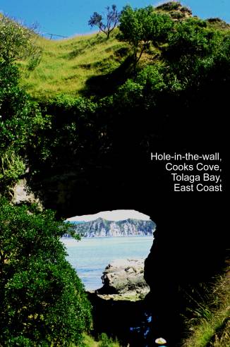
Gable End Foreland.
Map: Z17; Classification: C3. Significance: An unusually shaped, large
resistant slab of sandstone forming a prominent bluff.
Gisborne gas seep. Map: Y18; Classification: C1. Significance: Most accessible
and constant example of a natural gas seep on
Hole in the Wall,
Kirk's Clearing Upper
Cretaceous breccia. Map: X16; Classification: C3.
Significance: Channelised debris flow associated with
a Late Cretaceous growing fold. Type section of Kirk's Breccia Member, Whangai Formation.
Koranga Ridge Cretaceous fossil locality. Map: X17; Classification:
B3. Significance: Holostratotype of Korangan Stage in
Lottin Point melange. Map: Y14;
Classification: C3. Significance: Good example of melange.
Mangaehu Stream mud
volcano, Gisborne. Map: Y17; Classification: C2.
Significance: Site of two major historic mud eruptions in 1908 and 1930. Large mud mound with gentle gas and mud seepage on top at other
times.
Mangaotane Stream Cretaceous section, north Gisborne.
Map: X16; Classification: B3. Significance: Type section of Raukumara
Series, important reference section for the Cretaceous sedimentary sequences of
the
Mangapoi Stream volcanics. Map: Y15;
Classification: C3. Significance: Well exposed sequence of Rip Volcanics.
Mangapoike cuestas. Map: X18; Classification: B3. Significance: One
of few examples of cuestas in the
Matakaoa Point
marine terraces and shore platform. Map: Z14; Classification: C3. Significance:
A sequence of at least three well preserved marine terraces in association with
an impressive shore platform.
Maungahaumi nappes. Map: X17; Classification: C3. Significance: Most
easily visualised and historically earliest recognised thrust slices of the East Coast Allochthon on
Mawhai Point
razorback isthmus, Tokomaru Bay. Map: Z16;
Classification: C3. Significance: Razorback ridge connecting small promontory
to mainland. Unusual for this coastline.
Motu Falls Cretaceous section,
Mt Hikurangi klippe. Map: Y15; Classification: B3. Significance: Mt Hikurangi is the highest
nonvolcanic mountain in the
Muddy Creek Miocene section,
Muriwai Lagoon and spit,
Ormond Pleistocene plant
beds. Map: Y17; Classification: B3. Significance: Type locality of
several species, very well-preserved material.
Oweka Creek Pliocene macrofossils,
Potikirua Point Volcanics. Map: Y14; Classification: C3. Significance: Interbedded volcanics and microfossiliferous Early Eocene sediments.
Raukumara uplifted
"peneplain". Map: Y16; Classification: C3.
Significance: A high flat surface forms the crest of the
Tarndale and Mangatu slips. Map: X16; Classification: B3.
Significance:
Very active gullied earth flows surrounded by exotic forestation - some of the
most highly active in the
Tatapouri shore platform. Map: Y18; Classification: C3. Significance: A
wide planar shore platform formed due to rapid coastal erosion and retreat of
sea cliffs.
Tauwhareparae plateau. Map: Y16; Classification: B3. Significance: An
extensive low relief surface or tableland in contrast to deeply dissected
eroding surrounding country.
Te Araroa
beach ridges. Map: Z14; Classification: C3. Significance: One of the
best examples of beach ridges on the East Coast.
Te Araroa Upper Miocene section. Map: Z14;
Classification: B3. Significance: One of best exposed and most easily
accessed sequences of upper Miocene sedimentary rocks in East Coast region.
Continuous sequence with diverse warm water fauna and rich trace fossil
assemblage.
Te Kiwikiwi
pillow lava. Map: Z14; Classification: C3. Significance: Best evidence
for Eocene volcanism in
Te Puia Hot Springs.
Map: Z16; Classification: C2. Significance:
Te Puia
Springs earthflow and mud volcanoes. Map: Z16;
Classification: C3. Significance: A very large deep seated earthflow
affecting most of Te Puia Springs township.
Associated with thermal springs and mud volcanoes.
Te Rata Stream, Cretaceous sediments. Map:
X16; Classification: B3. Significance: Reference section of Whangai
Formation.
Tikihore Stream breccia. Map: Y16;
Classification: C2. Significance: Best known example of East Coast Volcanics,
Tiniroto landslide: Map X18; Classification: C3. Significance:
Extraordinary topography of hummocky landscape, lakes and wetlands dammed by
landslide debris.
Tutamoe Plateau. Map: Y16; Classification: C3. Significance: An
excellent example of a synclinal remnant of resistant sandstone forming a plateau.
Waiapu River delta. Map: Z15; Classification: C3. Significance:
Rapidly accreting river mouth with barrier forming.
Waikaremoana landslide. Map: W18; Classification: C3. Significance:
Landslide responsible for damming the
Waimata mud volcanoes. Map: Y17; Classification: B2. Significance:
Saline mud and gas seep and bubble out of a number of low conical mounds of
mud. One of the best and most accessible
Waiorongomai Gully.
Map: Y15; Classification: B3. Significance: Extremely large scale and deep
seated gullying in argillite, extremely active. A spectacular example, one of the best in
Waitangi oil shaft and oil
seeps. Map: Y17; Classification: B3. Significance: One of the best
preserved and earliest hand dug shafts in NZ.
Young Nicks Head,