Canterbury 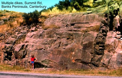
Akaroa Head Reserve lava
flows. Map: N37; Classification: C3. Significance: Lava flows containing gabbro and syenite nodules.
Alexandrina eskers. Map: I37; Classification:
B3. Significance: An example of a feature rare to
Annandale (Mt Cookson) karst, Waiau. Map: N32;
Classification: B3. Significance: Best
tomo development in eastern
Ant Stream alluvial
terraces. Map: L33; Classification: C3. Significance: Excellent, little
modified example of alluvial terraces. A sequence of about eight terraces
exists. Soils record sequence of downcutting of
Pleistocene terrace.
Arthurs Pass
terminal moraine loop. Map: K33; Classification: C3. Significance: Very well
preserved terminal moraine loop with radiocarbon date. A double moraine loop
encloses a swamp. Radiocarbon date indicates ice from upper
Ashley Fault. Map: M34; Classification: C3.
Significance: Late Quaternary traces of the Ashley Fault. Traces show minor S
side stepping of the fault and graben formation. Sense of vertical displacement N side up (W of graben)
and S side up (alongside and E of graben). RL
bend in stream across fault.
Avoca Point unconformities,
Awahokomo
karst pinnacles, Kurow.
Map: I40; Classification: C1. Significance: Farthest inland (west) exposure of Otekaike Limestone (approximate limit of marine
transgression in area). Spectacular karstic pinnacles. Tops of pinnacles form special plant habitat
for several native plants on critically endangered list.
Awatere Fault,
Balmacaan middle Triassic faunas.
Map: J36; Classification: A3. Significance: Torlesse
rocks with middle Triassic faunas including ammonoids.
Important in international correlation.
Ben Ohau rock
glacier. Map: H37; Classification: C3. Significance: One of the best examples
of a small rock glacier in the
Ben Ohau vein, folds
and fault structures. Map: H36; Classification: C3. Significance: Excellent
exposures of deformation in metagreywackes.
Benmore Dam faulted
greywacke. Map: H39; Classification: C2. Significance: A good example of
structure within the Torlesse terrane.
Benmore Permian fusulinids. Map: I39; Classification: A3. Significance: One
of only three fusulinid foraminifera
localities in
Black Jacks Triassic fossil macroflora, Benmore Dam.
Map: H39; Classification: B3. Significance:
Bland's Bluff paleokarst, Mt
Somers.
Map: K36; Classification: C5. Significance: Classic exposure of paleokarst and shoreline sedimentary facies.
Now destroyed by quarry "remedial" smoothing.
Blue Cliffs Miocene
macrofossils. Map: J39; Classification: B2. Significance: Diverse macrofauna and holostratotype of Otaian Stage.
Blue Slip, Kekerengu.
Map: P30; Classification: C3. Significance: Good representative example of a
coastal slip, involving montmorillonite clays.
Branch Stream faulted fan (Clarence Fault).
Map: O30; Classification: C3. Significance: Excellent example of fault
displaced alluvial fan.
Branch Stream gorge spring. Map: O30;
Classification: C3. Significance: A good example of a spring with a large flow
of cold clear water.
Branch Stream river terrace. Map: P30;
Classification: C3. Significance: A well developed stream terrace surface
grading back into mountain ranges. An unusual feature in this
area.
Broken
Broken River landslide.
Map: K34; Classification: C3. Significance:
Broken, Thomas and
Brooklands Lagoon
and reversed spit,
Brothers Stream Oligocene
fossils. Map: I40; Classification: B3. Significance: Diverse Waitakian molluscan fauna.
Bullock Creek debris flow.
Map: M34; Classification: B3. Significance: Very nice example of an eroding
gully, debris flow and debris flow fan.
Burnt Hill Miocene macrofossils. Map: L35;
Classification: B2. Significance: Diverse Waiauan macrofauna.
Bush Stream stilpnomelane.
Map: H37; Classification: C3. Significance: One of the region's best
occurrences of stilpnomelane-bearing schist.
Campbells Park School Oligocene molluscan fossils.
Map: I40; Classification: B3. Significance: Very diverse Waitakian
molluscan fauna.
Carneys Creek Triassic Torlesse
macrofossils. Map: I35; Classification: B3. Significance: Rich Torlesse macrofauna.
Carriage Drive alluvial fan. Map: O30;
Classification: C3. Significance: Unusually good example of high level remnants
of an alluvial fan.
Carriage Drive fault trace. Map: K35;
Classification: C2. Significance: Very recent fault trace in accessible area.
Carrington Peak moraine. Map: K33;
Classification: B3. Significance: A series of at least 5 closely spaced
"Little Ice Age" (1750 AD) moraines on the lip of a glacially cut
bench at the head of
Cass-Harper fault system. Map: K34;
Classification: C3. Significance: Spectacular late Quaternary NE trending fault
traces of the Cass-Harper fault system.
Castle Rock trachyte intrusion, Lyttelton
Volcano. Map: M36; Classification: A3. Significance: A well exposed trachyte dome with fanning columnar joints and good
intrusive contacts.
Catholic Cathedral, Christchurch. Map: M35;
Classification: C2. Significance: One of the most ornately carved Oamaru Stone buildings in NZ.
Celmisia Flat
moraine wall. Map: H36; Classification: B2. Significance: A very good example
of a moraine wall.
Charwell River
faulted terraces (Hope Fault). Map: O31; Classification: C2. Significance: Good
example of lateral fault displacement of terraces and channels.
Cheviot coast pillow lava. Map: O33;
Classification: C3. Significance: Good example of large pillows with radial
jointing.
Christchurch State Insurance building. Map:
M35; Classification: C1. Significance: Best example of use of Bluff Norite panels on a
Church of the Good Shepherd, Tekapo. Map: I37; Classification: C2. Significance: Well
known example of a building made of greywacke.
Clarence River delta and ventifacts.
Map: P30; Classification: C2. Significance: A large symmetrial
and classic cuspate delta composed of greywacke gravel and boulders. South of
the river mouth sand dunes contain limestone cobbles and boulders which have
been ventifacted.
Clarence River dikes and sills. Map: O30;
Classification: C3. Significance: Best exposure of Grasseed
Volcanics.
Clarence Valley Cretaceous fossil Trigonid beds. Map: O31; Classification: B3. Significance:
One of best preserved and richest Cretaceous trigonid
localities in New Zealand.
Clent Hills Jurassic
macroflora. Map: J36; Classification: B3.
Significance: Well-preserved Jurassic macroflora in Clent Hills Group.
Coleridge Creek Oligocene molluscan fossils. Map: K34; Classification: B3.
Significance: Diverse Duntroonian-Waitakian molluscan fauna.
Conical Hill rhyolite columns. Map: M36; Classification: C2.
Significance: Interesting exposure of inclined cooling columns in rhyolite.
Conway coast Holocene fossil forest. Map: O32;
Classification: C3. Significance: Excellent, easily accessible and visual
example of a Holocene fossil forest buried and preserved by coastal sediment.
Conway coast Pleistocene fan delta sediments
and trace fossils. Map: O32; Classification: B3. Significance: Excellent
exposures of uplifted late Pleistocene near-shore deltaic gravels and
inter-delta sandstones with slump and water expulsion structures and some of
best 3D exposures of shallow marine trace fossils in New Zealand.
Conway coast uplifted marine terraces. Map:
O32; Classification: C3. Significance: Sequence of 6 marine terraces of Waiwheran-Holocene age uplifted up to 300 m (Tarapuhi Terrace) and tilted to the N.
Cookson dolerite feeder. Map: O31; Classification: C3.
Significance: Well exposed dolerite feeder plug.
Copland Pass schist section. Map: H36;
Classification: B3. Significance: A section containing both soft sediment and
metamorphic structures.
Corbies Creek
Triassic macrofossils. Map: H40; Classification: B3. Significance: Rich
Triassic macrofaunas in Torlesse.
Counting Stream basanitoid.
Map: N32; Classification: C3. Significance: Contains mantle xenoliths.
Coverham Cretaceous fossils.
Map: P30; Classification: B3. Significance: Holostratotype
of disused Coverian Stage. Type locality of various
macrofossil species, rich ammonite faunas.
Cow Stream Springs. Map: M31; Classification:
C2. Significance:
Cox River rockslide. Map: L33; Classification:
B3. Significance: A good example by
Craigieburn pinnacles. Map: K34; Classification: C2. Significance: The
best local example of this feature. Formed by the erosion of
Tertiary conglomerates.
Crooked Spur moraines. Map: J36;
Classification: C3. Significance: Large latero-terminal
moraines of a Pleistocene valley glacier, best preserved example in the
Curiosity Shop fossiliferous
sequence and unconformities. Map: K36; Classification: B2. Significance: An
otherwise unknown unit (Highbank Sandstone) beneath
the Otekaike Limestone, the southern most occurrence
of Berrydale Greensand(?) on a rubbly
contact on Otekaike Limestone, and a top unit of
Curiosity Shop Sandstone with good shallow marine sedimentary structures.
Beautifully preserved molluscs, echinoids and shark
teeth.
Dart Stream fault exposure (Clarence Fault).
Map: O30; Classification: B3. Significance: Excellent exposure of high angle
reverse fault plane.
Dashing Rocks loess, Timaru. Map: K39; Classification: A2. Significance: Internationally
famous loess section - the site where John Hardcastle
observed and was 75 years ahead of anyone else in the world in describing loess
stratigraphy and recognising
the sequence as a record of past climates. Here he also was the international
trail-blazer in proposing the event-sequence approach to understanding loess
deposit formation and the first to describe fragipans
(characteristic hard layers) in loess. Of great significance in the history of
international earth science.
Deadman Stream
Miocene debris flows. Map: P30; Classification: C3. Significance: Excellent
section through representative beds of Great Marlborough Conglomerate.
Deans earthflow
complex. Map: M34; Classification: B3. Significance: A series of earthflows important due to being one of the best
Deans limestone
pavement, Waipara. Map: M33; Classification: C2.
Significance: The best example of proto-karst
pavement developing on one of many limestone dip-slopes in the
Denny Stream alluvial fans.
Map: J36; Classification: C3. Significance: Exceptionally well developed and
preserved Holocene alluvial fans with characteristic form.
Devils Gap intrusions. Map: N37; Classification: C3. Significance: Good
examples of trachyte plugs.
Diamond Slip bipyramidal
quartz. Map: K36; Classification: C3. Significance: Location of unusual bipyramidal crystals of quartz, mistaken for diamonds in
1860s.
Double Corner Miocene shellbeds.
Map: N34; Classification: C3. Significance: Diverse Waiauan
molluscs.
Double Hill roche moutonnee. Map: K35; Classification: C3. Significance:
Outstanding hill of greywacke basement sticking up through Rakaia
valley terraces.
Douglas moraine wall. Map: H36;
Classification: B3. Significance: A spectacular and well defined moraine wall.
Dovedale Stream
Upper Cretaceous to mid-Tertiary sediments. Map: N34; Classification: C3.
Significance: Good section through North sequence.
Dryburgh Fault. Map:
I40; Classification: C3. Significance: Major reverse fault system in the Waitaki Basin, with obvious topographic expression and
Quaternary offset. System of splay faults form a zone c.500 m wide, where
Tertiary sediments overthrust Quaternary gravels and
greywacke overthrusts Tertiary along moderately steep
angle contacts (55 degrees). Extensive crush zones in greywacke.
Dubious Flat fault trace. Map: O30;
Classification: C3. Significance: Good example of fault trace and sag pond.
Earthquakes Oligocene fossiliferous
sediments. Map: I41; Classification: B3. Significance: Important reference
section for Otekaike Limestone and regional
intra-Oligocene unconformity. Good vertebrate fossil locality in Kokoamu Greensand bed.
Ellangowan trachyte dome. Map: N36; Classification: C3. Significance:
Good example of a trachyte dome.
Esk Head Melange. Map: M34; Classification: C3. Significance: A
prime example of Esk Head Melange.
Esk Head Station cob
homestead. Map: M33; Classification: B2. Significance: An excellent example of
cob (and some pise de terre)
homestead construction.
Esk Head Triassic mollusc fossils. Map: L33; Classification: B1.
Significance: Unique association of the molluscs Monotis, Halobia and Manticula in same limestone block.
Ethelton School
Miocene shellbed. Map: N33; Classification: C3.
Significance: Rich and diverse Tongaporutuan fauna.
One of best in Canterbury.
Euscalpellum
locality (Paleocene "barnacle" stalks). Map: M34; Classification: A3.
Significance: Unique occurrence of abundant "barnacle" stalks of
international interest. One of few Paleocene macrofossil
localities in
Evan's Crossing Eocene
macrofossils. Map: J39; Classification: B2. Significance: Diverse mid
Eocene macrofauna in New Zealand, in glauconitic
sandstone.
Eyre River Eocene foraminifera. Map: L35; Classification:
C3. Significance:
Only large foraminifera in New Zealand of Mangaorapan
age.
Falling Mountain complex landslide. Map: K33;
Classification: B3. Significance: A spectacular example of a complex landslide.
Flock Hill box syncline. Map: K34;
Classification: C3. Significance: Good example of fault controlled drape fold
in a thrust bound late Cenozoic basin.
Flock Hill solifluction
features. Map: K34; Classification: C3. Significance: Solifluction
features and limestone block fields existing alongside rockfalls
and topples.
Foveran sarsen stones. Map: I40; Classification: C3. Significance:
Remnant Sarsen stones after stripping off of Tertiary
cover. Particularly good example of an extensive group of Sarsen stones.
Fox's Peak Fault, Dobson skifield
to Firewood Stream. Map: I37; Classification: C3. Significance: Example of
progressive vertical displacement of late Quaternary terraces on the S part of
the Fox's Peak Fault. Maximum displacement of 8 m (W side up) and youngest
terrace offset of 0.5 m. Terraces generally younger than 16000 years. Regarded
as a reverse fault, with traces distributed across a c.2 km wide zone.
Fox's Peak Fault, Tasman Ski Club. Map: J37;
Classification: C3. Significance: Example of active traces in basement, and
range front "scalloped" nature of the Fox's Peak reverse fault in the
N.
Gebbies Pass
Cretaceous plant beds. Map: M36; Classification: C2. Significance: Only
Cretaceous macroflora for 60 km. Important in dating
earliest Banks Peninsula volcanics.
Gebbies Pass
obsidian hill. Map: M36; Classification: C3. Significance: Good example of
banded obsidian representing the roots of a rhyolite
dome and interesting geomorphology of weathered rhyolites.
Glen Muick
discordant beds. Map: N33; Classification: C2. Significance: Evidence for
deformation during Pliocene.
Glenafric Miocene
crab fossils. Map: N34; Classification: B1. Significance: Common large crabs in
weathered concretions, Tumidocarcinus giganteus.
Glenfalloch Stream
Permian fusulinid locality. Map: J35; Classification:
B2. Significance: One of only three fusulinid
foraminifera localities known in New Zealand.
Glenmark Limestone
Miocene mollusc and bryozoan
fossils. Map: M34; Classification: A3. Significance: Diverse Waiauan molluscs. Abundant and
well-preserved bryozoans.
Glenmore Station kame.
Map: I37; Classification: B3. Significance: A very large example of kame - the best in
Glenstrae
Pleistocene fossils. Map: O32; Classification: B3. Significance: Most diverse bathyal Pleistocene fauna in New Zealand.
Glentanner Syncline. Map: H37; Classification: C2. Significance: An
example of late deformation of the Alpine Schists.
Godley River debris covered glacier. Map: I36;
Classification: B3. Significance: A debris covered glacier.
Goldney Hill rock
avalanche deposit. Map: K35; Classification: A3. Significance: The largest rock
avalanche deposit in the central Southern Alps. Viewed from point K34962702 it
is one of the most impressive in
Greenwood Formation Pliocene
fossils. Map: N34; Classification: C3. Significance: Best of very few
late Pliocene shallow-water faunal localities in North Canterbury.
Haeckel Fold,
Murchison Valley. Map: I36; Classification: C3. Significance: An example of
macroscopic folding.
Haehae Te Moana Permian fossils. Map: J37; Classification: B3.
Significance: Richest Permian fauna in Torlesse
rocks.
Hakatere kettle
lakes. Map: J36; Classification: C3. Significance: Excellent examples of kettle
lakes, left by receding glacier.
Hamner Springs. Map:
N32; Classification: C1. Significance:
Happy Valley fault exposure (Hope Fault). Map:
P30; Classification: C3. Significance: Large exposure of Kekerengu
Fault where history of late Quaternary fault motions can be seen.
Hapuku River faulted
terraces (Hope Fault). Map: O31; Classification: C2. Significance: Excellent
site to study the displacement and timing of movement on one of New Zealand's
most active faults.
Harman Pass block field. Map: K33;
Classification: B3. Significance: Very large and distinct example of a block
field.
Harper Hills Basalt. Map: L35; Classification:
C3. Significance: The youngest volcanics in Coalgate
area.
Haumuri Bluff Upper
Cretaceous sediments and fossils. Map: O32; Classification: B2. Significance: A
classic locality exposing the late Cretaceous sequence of Marlborough. Holostratotype of Haumurian and Piripauan Stages. Type locality for many late Cretaceous molluscs and vertebrates. Well preserved macro and microfloral remains.
Hemphill alluvial fan. Map: H39;
Classification: C3. Significance: A spectacular alluvial fan, the largest in Otago.
Hinds River Tertiary strata reference section.
Map: J36; Classification: C2. Significance: Reference section through almost
complete succession of Tertiary rocks in central Canterbury.
Hogs Back syncline. Map: K34; Classification:
C3. Significance: Good example of a vertical fold in a thrust bound late
Cenozoic basin.
Holmes Bay cinder cone. Map: N36;
Classification: C3. Significance: Well exposed and accessible section through a
cinder cone.
Homebush brick, tile
and pottery works, Glentunnel. Map: L35;
Classification: C3. Significance: The main brickpottery
works in the area.
Hope Fault, Glynn Wye
Station. Map: M32; Classification: A3. Significance: The site at which A. McKay
recognised and mapped transcurrent
faulting from the 1888 Amuri earthquake. This was the
first recognition of transcurrent faulting in the
world.
Hope Fault, Hope River faulted terraces. Map:
M32; Classification: B2. Significance: Progressive RL displacement of late
Quaternary terraces of 150 m and 1888 rupture of 2.6 m [Total RL displacement on
fault c.20 km]. Graben formation and minor doming at
en echelon stepsbends in fault trace (eg Glynnwye Lk
depression). Smaller scale version of Hanmer basin.
Hope River Springs. Map: L32; Classification:
C2. Significance:
Hundalee Hills deep
sea canyon. Map: O32; Classification: B4. Significance: Preserved wall of late
Pliocene deep sea canyon.
Hurunui River
sandstone diapirs. Map: O33; Classification: C3.
Significance: Good example of diapirs recording
episode of deformation.
Hurunui River
Springs. Map: L32; Classification: C2. Significance:
Hurunui River, Ethelton Conglomerate. Map: N33; Classification: C3.
Significance: Good exposures of sediments and facies
of this age.
Jam Stream levees. Map: O30; Classification: C3.
Significance: Unusually well-defined levees on each side of the dry upper
reaches of the Jam Stream, formed by debris flows.
Jam Stream sawcut
gorge. Map: O30; Classification: C3. Significance: An impressive, narrow and
deep gorge.
Joseph Stream meanders. Map: I37;
Classification: B3. Significance: Random walk meander.
Jumped Up Downs. Map: J35; Classification: C2.
Significance: Excellent example of roche moutonnee.
Kaikoura beach
ridges. Map: O31; Classification: B2. Significance: Beaches that record the
history of tectonic uplift over the past several thousand years.
Kaikoura Inland Road
Oligocene macrofossils. Map: N32; Classification: C3. Significance: Diverse and
unusual shallow-water hard-bottom macrofauna at top
of volcanics. One of few good localities for fossil Haliotids.
Kaikoura Peninsula
raised marine terraces. Map: O31; Classification: C3. Significance: Easily
observed sequence of four uplifted marine terraces.
Kaikoura Peninsula
shore platform and folding. Map: O31; Classification: C3. Significance: Classic
example of an extensive wave-cut platform in limestone bedrock. Exposed in the
shore platform rocks is spectacular polyphase
folding. A good example of deformation in the East Coast Deformed Belt, as well
as a fine example of dome and basin, superimposed folds.
Kaitorete Barrier.
Map: M37; Classification: B2. Significance: A 25 km long gravel-pebble barrier
spit. Only significant dune system remaining intact on the
entire east coast of the
Kaiwara River
sedimentary collapse structures. Map: N33; Classification: C3. Significance:
Excellent example of sandstone dikes and associated collapse structures.
Kaiwara Syncline
Tertiary disconformities. Map: N33; Classification: B3. Significance: Exposures
of two important disconformities (Dh-Dp and Ab-Po) and of clastic dikes.
Kakahu Bush lime
kiln. Map: J38; Classification: C2. Significance: Well preserved example of
1880s lime kiln.
Kakahu Marble
Carboniferous locality. Map: J38; Classification: B3. Significance: Only known
Carboniferous sedimentary rocks in
Kakahu River Eocene molluscan fossils.
Map: J38; Classification: B1. Significance: Diverse Bortonian
molluscan fauna.
Kirkliston Fault.
Map: I39; Classification: C3. Significance: Zone of late Tertiary to late
Quaternary deformation of up to 3 km in width, associated with range front (Kirkliston Range) reverse faulting, gently backtilted and offset fan surfaces, and deformed Tertiary
and Quaternary sediments.
Kirkliston Range multicoloured metahyaloclastite.
Map: I39; Classification: B3. Significance: Excellent example of a lens of
spectacular metamorphosed hyaloclastite pillow lava breccia.
Kohurau patterned
ground. Map: I40; Classification: B2. Significance: Spectacular array of stone
polygons and stone stripes.
Kokoamu Bluff
Eocene-Oligocene unconformity and Oligocene brachiopods. Map: J40;
Classification: B3. Significance: Mid Oligocene unconformity below brachhiopod-rich Kokoamu
Greensand.
Lake Alexandrina moraine features. Map: I37;
Classification: B3. Significance:
Lake Browning tarn. Map: K33; Classification:
C3. Significance:
Lake Catherine alluvial fan. Map: K34;
Classification: B3. Significance: A good example of an hour-glass alluvial fan
damming Lake Catherine. The fan is virtually unmodified by erosion, so that all
material eroded from Mt Ida is stored in the fan.
Lake Coleridge spillway channel. Map: K35;
Classification: C3. Significance: Excellent example of a spillway channel
resulting from lake drainage and cut into outwash material. Channel carried
water from
Lake Heron Fault, alluvial terrace offset.
Map: J36; Classification: C3. Significance: Well-preserved example
of active fault trace displacing alluvial terraces.
Lake Heron Fault, Ashburton
River south branch. Map: J36; Classification: C3. Significance: Well-preserved
example of active fault trace.
Lake Heron Fault, moraine draped scarps. Map:
J36; Classification: C3. Significance: Late Otiran
moraine draped fault scarps and 1 m (W side up) post moraine traces along the
Lake Heron reverse fault.
Lake Heron glacial valley. Map: J35;
Classification: B2. Significance: Spectacular intermontane
valley with well preserved examples of landforms formed during a succession of
glacial advances.
Lake Minchin debris dam. Map: L33;
Classification: C3. Significance: Best example of a rock avalanche dammed lake
in
Lake Pukaki lateral
moraine. Map: H37; Classification: B3. Significance: A classic example because
of the scale of moraine.
Lake Pukaki terminal
moraine. Map: H38; Classification: B3. Significance: A well defined sequence of
terminal moraine.
Lake Sumner Torlesse
structures. Map: M32; Classification: B3. Significance: A good representative
section of typical structures in Torlesse rocks.
Lake Tennyson. Map: M31; Classification: C2.
Significance: A series of terminal moraines impounds
Lake Waitaki
Oligocene fossils. Map: I40; Classification: B3. Significance: Well-preserved
diverse Duntroonian molluscan
fauna. Also Kekendon toothed-whale teeth.
Lakes Sumner, Katrine,
Mason, Sheppard and Taylor. Map: L32; Classification: B3. Significance:
Excellent examples of lake features in a formerly glaciated environment. Lakes
occupy bedrock hollows and are impounded by moraines or fluvioglacial
deposits, originating from ice lobes of the Hurunui
glacier.
Lambert gorge. Map: I35; Classification: C3.
Significance: A very good example of a sawcut gorge.
Landslip Creek lateral moraine. Map: I37;
Classification: B3. Significance: Superb example of lateral moraine, the best
in
Le Bons Bay Peak basanite plug. Map: N36; Classification: C3. Significance:
A basanite plug which contains abundant inclusions of
ultramafic rocks.
Leader River Pleistocene macrofossils. Map: O32;
Classification: B3. Significance: Only good Castlecliffian
macrofauna in South Island.
Leamington mud
volcano. Map: N33; Classification: C2. Significance: Best example of a mud
volcano in
Leamington River
Miocene unconformity. Map: N33; Classification: C2. Significance: Excellent
exposure of contact of coarse conglomerate (Tongaporutuan)
on Cretaceous to Paleocene sandstone and greensand.
Leamington River
Pliocene conglomerate. Map: N33; Classification: C3. Significance: Excellent
exposure of intraformational folding.
Lewis River Springs. Map: M32; Classification:
C2. Significance:
Limestone Glens cannon-ball concretions. Map:
N33; Classification: C2. Significance: Rare example of concretions in massive
sandstone of Torlesse rocks.
Limestone Hill tuff and basalt. Map: O30;
Classification: C3. Significance: Type location of Grasseed
Volcanics.
Linwood relict dune. Map: M35; Classification:
C2. Significance: A relict dune from an ancient dune field - a good example of
many such features in
Little Lottery River nephelinitoid.
Map: N32; Classification: C3. Significance: Contains mantle xenoliths.
Long Hill terminal moraine and tarn. Map: L34;
Classification: C3. Significance: Terminal moraine is poorly defined as it is
covered by a post glacial tarn.
Lower Conway Railway Cutting
Cretaceous-Tertiary boundary. Map: O32; Classification: C3. Significance: Good
section through upper Cretaceous and Paleogene,
including unconformity of Paleocene age (Teredo
Limestone).
Lynton Downs faulted terrace (Hope Fault).
Map: O31; Classification: C2. Significance: Good example of displacement
movement and rates on Hope Fault.
Lyttelton Harbour mud flats. Map: M36; Classification: C3.
Significance: A very large and excellent example of mud flats.
Lyttelton Springs.
Map: M36; Classification: C2. Significance:
Macaulay scree
fault. Map: I36; Classification: C2. Significance: Fault trace that has
displaced active scree surface. Rock avalanche occurs
nearby (I36207263), and house-size boulders have fallen in the general Macaulay
catchment within the last few years.
Malvern Hills Jurassic plant
beds. Map: L35; Classification: B3. Significance: Well preserved fossil
plant beds.
Maori Leap Cave, Kaikoura. Map: O31; Classification: C2. Significance: Most
easily accessible speleothem cave in north
Mathaias River Triassic macrofossils. Map: J34; Classification: A3.
Significance: Rich Torlesse macrofauna
including well-preserved Trigonia.
McCulloch's Bridge Eocene fauna and
unconformity. Map: J40; Classification: B2. Significance: Extremely diverse Bortonian and Kaiatan molluscan faunas as well as boundary stratotype
for these two stages and stratotype of disused Tahuian Stage. Unconformity marked by phosphatic
concretionary layer, possibly correlated with a drop in sea level at 39.5 Ma.
McLean Stream offset terraces (Kekerengu Fault). Map: P30; Classification: C2. Significance:
Good example of terraces offest by recent movement on
the Kekerengu Fault.
Mead Stream Amuri
Limestone. Map: P30; Classification: A3. Significance: Most complete documented
sequence of 'Amuri Limestone' (Muzzle Group)
including all constituent formations - Mead Hill Formation, Lower Limestone,
Lower Marl, Middle Limestone, Upper Marl. Very complete latest Cretaceous to
mid Eocene record, including well-defined K-T boundary defined by foraminifera,
dinoflagellates and radiolarians. Only record worldwide
of a thick chert unit in the basal Paleocene (30 m
thick diatomite). Well-defined Late Paleocene unconformity at base of 2 m thick
black siltstone between siliceous limestone.
Mikonui earth flow.
Map: O32; Classification: C2. Significance: A good example of an earth flow.
Moncks uplifted sea cave,
Motunau Beach
Pliocene fauna and Pleistocene debris flows. Map: N34; Classification: A3.
Significance: Diverse fauna of crabs and molluscs.
Only Pliocene fossil penguin bones in New Zealand. Giant toothed seabird bones.
Crabs and birds are Nukumaruan. A
fossil underwater canyon, with Miocene boulders. Unconformably
overlain by large scale Pleistocene debris flow deposits.
Motunau Island. Map: N34; Classification: C3. Significance: Largest of uncommon small islands and islets off the
east coast of the
Mounds of Misery moraine. Map: L33;
Classification: C3. Significance: A good example of Late Pleistocene moraine
that is little modified. Moraine is from a lobe of ice from East Poulter that spilled into Nigger Stream about 14,000 years
ago. As stagnant ice melted jumbled piles of moraine were formed.
Mt Alford Coal Measures.
Map: K36; Classification: B3. Significance: Good exposure of a unit rarely
found.
Mt Cass proto-karst. Map: N34; Classification: C2. Significance:
Most extensive and the best example of a forested limestone left in the eastern
Mt Edith patterned ground. Map: J37;
Classification: B3. Significance: An area of patterned ground is covered in
tussock and thus easily discernable.
Mt Enys scree slope. Map: K34; Classification: C3. Significance: A
good example of very large scree slopes, avalanche
chutes and talus fans.
Mt Fyffe Station faulted fan (Hope Fault).
Map: O31; Classification: C3. Significance: Good example of a locality where
slip rates have been determined from offset of a fan surface on the Hope Fault.
Mt Glenmary debris
covered glacier. Map: H37; Classification: B3. Significance: A debris covered
glacier.
Mt Hay axinite. Map:
I37; Classification: C3. Significance: One of the most accessible and well
exposed known occurrences of axinite.
Mt Horrible volcanics. Map: J39; Classification: C3. Significance: The
youngest volcanics in the South Island.
Mt Joseph cirque. Map: I37; Classification:
C3. Significance:
Mt Mason pillow lava.
Map: M33; Classification: C2. Significance: Good example of upper Triassic
pillow lava.
Mt Mason Triassic limestone. Map: M33;
Classification: B3. Significance: Rich fauna of conodonts
and the bivalve Monotis, not in melange
sandstone.
Mt Olympus rock glacier. Map: K34;
Classification: B3. Significance: Excellent well preserved example of a rock
glacier deposit with well developed transverse furrows.
Mt Potts Triassic fossil flora and fauna
(Lizard Gully). Map: J35; Classification: B3. Significance: Rich Triassic macroflora and rich Torlesse macrofauna of brachiopods, bivalves, nautiloids
and vertebrates.
Mt Potts Triassic plant beds (Tank Gully).
Map: J35; Classification: B3. Significance: Well preserved fossil plant beds.
Mt Somers Paleogene
tidal sand quarry. Map: K36; Classification: B3. Significance: Excellent
cutting through this feature; best in Canterbury.
Mt Somers volcanics.
Map: K36; Classification: C3. Significance: Type area of Late Cretaceous Mount
Somers Volcanic Group.
Mt Sugarloaf roche moutonnee. Map: J35; Classification:
C3. Significance:
Excellent example of a roche moutonnee
hill overidden by ice with classic asymmetric shape
and glacial striations. Prominent peak at east end of Lake Heron.
Mt Sunday island. Map: J36; Classification:
C3. Significance: High island in Rangitata River
valley composed of bedrock that has been overridden by the Rangitata
glacier that has ice-sculpted the terrain.
Mt Vulcan rock block slide. Map: N34;
Classification: C3. Significance: A good example of mass movement involving bentonite soils.
Mt White Station kame
terraces. Map: L34; Classification: B3. Significance: Particularly good
examples of kame terraces by
Multiple Dikes, Lyttelton
Volcano. Map: M36; Classification: A2. Significance: Excellent example of
multiple dike intrusions.
Napenape coastal landslide. Map: N33; Classification: C3.
Significance: One of the best examples
of semi-active bentonitic mass movement features in
Nigger Stream moraine and
terraces. Map: L33; Classification: C3. Significance: Good examples of
glacial and fluvial landforms. Latero-terminal
moraine loops record the extent of the Blackwater age
ice advances. Nigger Stream has subsequently cut through this sequence forming
a series of terraces.
North Kaikoura
Peninsula Cretaceous hard-bottom fossils. Map: O31; Classification: C2.
Significance: Unusual relatively rich hard-bottom fossil fauna of late Creatceous age.
Ohinetahi Homestead,
Okana River delta.
Map: N36; Classification: B2. Significance: Best example of a cuspate delta in
the
Okuku Triassic Monotis locality. Map: M34; Classification: B1.
Significance: White blocks of limestone in melange,
crammed with Monotis and many conodonts.
Richest Monotis locality in Torlesse
rocks.
Old Chemistry building, Christchurch Arts
Centre. Map: M35; Classification: B2. Significance: One of the best examples of
the use of a wide variety of local stones in a building.
Omarama badlands
(Clay Cliffs). Map: H39; Classification: B3. Significance: Spectacular area of
badlands, erosion features and earth pillars.
Onepunga Miocene bryozoan locality. Map:
M34; Classification: B2. Significance: Exceptionally rich bryozoan
limestone.
Opihi Lagoon and Harakeke Tautoro Island. Map:
K38; Classification: B2. Significance: An excellent example of a mixed sand and
gravel barrier island enclosing a rare distinctive type of lagoon.
Opihi taniwha rock drawing. Map: J38; Classification: B2.
Significance: Well known prehistoric art site in
Ostler Fault zone,
Ostler Fault zone,
'The Knot'. Map: H39; Classification: A2. Significance: Example of variation in
form of traces associated with reverse fault movement, including a major 90
degree bend ('The Knot'). Terraces have maximum scarp heights of 15 m on
surfaces c.20000 years old. This site is monitored for precise strain
measurements by the Earth Deformation Section, New Zealand Geological Survey.
Ostler Fault zone, Willowbank Saddle. Map: H39; Classification: B3.
Significance: Oldest recognised surface that the Ostler Fault zone crosses (>120000 years), with 80 m
vertical displacement and post glacial offsets along it's toe.
Ostler Fault, Ohau River faulted terraces. Map: H38; Classification: B3.
Significance: Example of progressive displacement of late Quaternary terraces.
Up to 21 m vertical offset (NW side up) on surfaces 20000 years old. Youngest
terraces disturbed and some inundated by Lake Ruataniwha.
This site is monitored for precise strain measurements by the Earth Deformation
Section,
Otaio River Paleogene fossiliferous
sediments. Map: J39; Classification: B2. Significance: Good exposure
through Eocene to Miocene, including unconformities. Best documented upper Dannevirke molluscan fauna in
Panama Rock and feeder dike, Akaroa Volcano. Map: N36; Classification: A3. Significance:
Rare example of trachyte dome with well exposed
feeder dike.
Parapet Rock offset fault trace. Map: K34;
Classification: B2. Significance: A good example of strikeslip
rotational faulting illustrated by an offset fault trace.
Pareora dolines. Map: J39; Classification: C3. Significance: Most spectacular sinkhole plains formed in Tertiary
limestone in
Pareora Gorge pillow lava and banded chert.
Map: J39; Classification: C2. Significance: Excellent example of pillowed metabasalt and associated banded chert
and argillite with rare manganaxinite disseminations.
Pareora River Miocene molluscan fossils. Map: J39;
Classification: B3. Significance: Diverse well-preserved molluscan
fauna.
Porters Pass Fault, Lake Coleridge faulted
terraces. Map: K35; Classification: C3. Significance: RL displacement of late
glacial terraces along the Porters Pass fault [RL strike slip fault]. Up to
c.10.2 m RL and 6.6 m vertical (N side up) displacement of highest terrace.
Porters Pass Fault, Lake Coleridge power
station trace. Map: K35; Classification: C3. Significance: SW extension of the
Porters Pass Fault not previously mapped. Fault trace shows vertical
displacement and surface en echelon features. Site extends to K35903597.
Porters Pass Fault, Otarama
trace. Map: L35; Classification: C3. Significance: Recent fault scarp (N side
up) of the Porters Pass fault [RL strike slip fault].
Porters Pass Fault, Porters Pass-Lake Lyndon
trace. Map: K35; Classification: C3. Significance: Recent fault scarps (S side
up) and exposure of buried soils faulted against greywacke in crush zone along
Porters Pass Fault [RL strike slip fault]. Obvious hillside scarps to the east
near Lake Lyndon.
Poulter River
terraces. Map: L34; Classification: C3. Significance: A well preserved sequence
of terraces on the east side of the
Poverty Flat fan and glacial
lake shorelines. Map: L34; Classification: B2. Significance: Very well
preserved example of a rare landform.
Pudding Hill Stream Triassic fossils. Map:
K36; Classification: B3. Significance: Several localities containing faunas
that show a relationship between Torlesse and non-Torlesse Triassic.
Pudding Valley landslide and dammed lake. Map:
J36; Classification: C3. Significance: Well-defined rock avalanche that has
dammed Lake Denny.
Pudding Valley mouth terraces and
ice-sculptured terrain. Map: J36; Classification: C3. Significance: Complex
landforms comprising overridden ice-sculptured terrain with spectacular river
terraces, alluvial fans and fault scarps.
Puhi Puhi Syncline, Mt Alexander. Map: P31;
Classification: C3. Significance: Very good geologic and geomorphic example of tight
folding of infaulted resistant Cretaceous-Tertiary
sediments along the foot of the
Pulpit Rock intrusion.
Map: N36; Classification: C3. Significance: Good example of a trachyte plug-like intrusion.
Pyramid Valley Holocene swamp. Map: M33;
Classification: B2. Significance: Well-known locality containing rich and
diverse moa and bird bones, including numerous complete moa skeletons.
Quail Flat cookhouse, Clarence Valley. Map:
O31; Classification: C2. Significance: A good example of a cob cottage still in
use.
Quail Island volcanic features. Map: M36;
Classification: B3. Significance: Compact area in which a wide variety of
volcanic features can be observed.
Racecourse Hill outwash terrace. Map: L35;
Classification: C3. Significance: One of three remnants of an extensive outwash
terrace from the oldest known ice advance (early Pleistocene) in the
Ragged Range protalus rampart. Map: J34; Classification: C3.
Significance: A particularly good example of a protalus
rampart. Uncommon in New Zealand.
Rakaia Gorge and
terraces, with amethyst and garnet-bearing rhyolites.
Map: K35; Classification: A3. Significance: Extremely well preserved and text
book example of a sequence of alluvial terraces, with spectacular exposures in
road cuttings. Garnet-bearing rhyolites
with some of the best examples of amethystine quartz in
Rakaia Gorge varves. Map: K35;
Classification: B2. Significance: One of the best exposures and most easily
accessible sites to view glacial lake varves in
Rangitata ice-margin features. Map: J36; Classification:
B3. Significance:
A complete sequence of glacial features on valley side slope providing a record
of ice levels during glaciation and deglaciation intervals in the Rangitata.
Rangitata outwash terraces. Map: J36; Classification: C3.
Significance:
Excellent example of outwash river terracing (up to 7
in places)
Rapaki Dike. Map:
M36; Classification: C3. Significance: Good example of a radial trachyte dike.
Raramai sea arch, Kaikoura. Map: O31;
Classification: C2. Significance: Excellent example of a scenic sea arch
visible to travellers on SHW 1.
Redcliffs Stream Tertiary sequence. Map: K35; Classification: C3.
Significance: Isolated infaulted block of Tertiary
strata, overlain by high-level glacial morraine
deposits.
Redcliffs uplifted
sea caves,
Remarkable Dikes.
Map: M36; Classification: C3. Significance: Two thick trachyte
dikes which form a prominant skyline feature.
Rocky Gorge coal measures. Map: J35;
Classification: C3. Significance: Best exposures of facies
of this age in western Canterbury.
Rubicon torrent rock slide. Map: H36;
Classification: B3. Significance: One of
Ryton Valley debris
flow. Map: K34; Classification: A3. Significance: An internationally
significant example of a debris flow.
Sawyers Creek faulted terrace (Hope Fault).
Map: O31; Classification: C2. Significance: Clear example of displacement of a
late Quaternary terrace on the Hope Fault.
Scenery Nook Strombolian cone. Map: N37; Classification: B3.
Significance: Superb section through a Strombolian
cinder and tuff cone.
Seymour Stream basalt flows
and coal measures. Map: O31; Classification: B3. Significance: Well
exposed sequence of Cretaceous non-marine sediments and overlying basalt flows.
Seymour Stream complex
landslides. Map: O31; Classification: C3. Significance: Good example of
complex landslides.
Seymour Stream dip slope. Map: O31;
Classification: C3. Significance: Good example of a dip slope hillside
developed on tilted lava flows.
Sheffield Hill outwash terrace. Map: L35;
Classification: C3. Significance: One of three remnants of an extensive outwash
terrace from the oldest known ice advance (early Pleistocene) in the
Sisters Creek Oligocene
fossils. Map: I40; Classification: B3. Significance: Diverse Waitakian macrofauna including
whales, brachiopods and corals.
Smite River Oligocene fossil shark teeth. Map:
J35; Classification: C3. Significance: Abundant shark teeth in greensand.
Locality originally collected by Haast.
South Kaikoura
coastal features. Map: O31; Classification: C3. Significance: Good example of
steeply cliffed coast, rocky headlands and stacks,
appreciated by all users of highway 1.
South side Kaikoura
Peninsula Marshall Paraconformity. Map: O31;
Classification: C3. Significance: One of best and most easily accessible
exposures of Marshall Paraconformity within Oligocene
sequence.
Springfield Hill outwash terrace. Map: L35;
Classification: C3. Significance: One of three remnants of an extensive outwash
terrace from the oldest known ice advance (early Pleistocene) in the
Spy Glass former sea arch. Map: O32;
Classification: C3. Significance: A prominent and attractive feature eroded
along joints through muddy limestone. Arch collapsed in 2007 leaving a tall
spire.
Squires Farm Oligocene Marshall Paraconformity. Map: J39; Classification: B3. Significance:
Type section of the nationally important Oligocene Marshall Paraconformity.
Rich unusual brachiopod fauna.
St Anne's Church, Pleasant Valley. Map: J38;
Classification: C2. Significance: Rare, if not unique example of cob
construction in a church in New Zealand.
St Mary's Church, Timaru.
Map: K39; Classification: C2. Significance: Most prominent building made of Timaru Basalt.
Staveley lime kilns.
Map: K36; Classification: C2. Significance: A good example of historic lime
kilns.
Stour River West
Branch U-shaped glacial valley. Map: J36; Classification: C3. Significance:
Excellent example of a U-shaped glacial valley, especially visible from Mt
Somers track.
Sutherlands Miocene molluscan fossils. Map: J38;
Classification: B3. Significance: Diverse well-preserved Altonian molluscan fauna.
Swin River alluvial
fan. Map: J35; Classification: B3. Significance: A fan drains both to NW (most
active) into Rakaia catchment
via Lake Heron and to the SW into the Ashburton River
catchment. Unusual for a fan to be at drainage
divide.
Takiroa shelter rock
drawings, Waitaki Valley. Map: I40; Classification:
B2. Significance: First prehistoric drawings recorded by a European.
Tasman Glacier. Map: H36; Classification: A3.
Significance: Longest glacier in New Zealand and most accessible glacier on the
east side of the Southern Alps.
Tasman Glacier Blue Lakes moraine. Map: H36;
Classification: B3. Significance: An excellent and easily accessible example of
moraine dammed lakes, including very good examples of ablation moraine and
moraine kettles.
Tasman River outwash plain. Map: H37;
Classification: C3. Significance: One of the biggest fluvio-glacial
outwash plains in
The Brothers volcanic plug. Map: K36;
Classification: C3. Significance: The youngest volcanic rocks in the Mt Somers
area, well exposed. Forming a prominent small hill.
The Cathedrals Rock pillars. Map: O33;
Classification: B3. Significance: One of the best examples in New Zealand of
large-scale badlands erosion. Prominant examples of
an unusual feature, 12-16 m high.
The Desert, Clarence Valley. Map: O30;
Classification: C3. Significance: A spectacular desert-like landscape of bare
ground (including lag surface, gullies and rills) and poor vegetation.
Timaru fossil forest. Map: K38; Classification: C2. Significance: Good
example of a late Quaternary fossil forest.
Tiptree Cottage, Harewood. Map: M35; Classification: C3. Significance: A
very good example of cob construction.
Trig H Limestone. Map: K36; Classification:
B3. Significance: Excellent exposure of foreset crossbedding.
Trig Z Otekaike paleokarst, Kurow. Map: I40;
Classification: B3. Significance: Excellent exposure of late Oligocene paleokarst and shallow water facies.
Very diverse Waitakian molluscan
fauna, and holostratotype for Waitakian
Stage (substage of Park 1918).
Turkey Flat alluvial fan. Map: K34;
Classification: B3. Significance: Best example of a low gradient alluvial fan
in the country.
U Sub amydaloidal
pillowed metabasalt and hyaloclastite.
Map: N33; Classification: C2. Significance: Large outcrops of amygdaloidal
radial jointed pillowed metabasalt and hyaloclastite with interbedded fossiliferous limestone.
Upper Tengawai River
Oligocene fossils. Map: I38; Classification: B3. Significance: Diverse Waitakian molluscan fauna.
Vagabonds Inn kettle lake. Map: L34;
Classification: B3. Significance: A well defined kettle lake in a region of
tarns and remnant moraines.
View Hill trachyte
dome. Map: N36; Classification: C3. Significance: A good example of a trachyte dome.
Waihao Box and Wainono Lagoon system, Waimate. Map: J40; Classification: B2. Significance:
An unusual occurrence of a lagoon and river system paralleling the coastline,
but with no natural opening to the sea. Wainono
Lagoon is the 4th largest barrier-enclosed coastal lagoon on the east coast of
the
Waihao Downs Eocene molluscan fossils. Map: J40;
Classification: B3. Significance: Diverse Bortonian molluscan fauna.
Waihao
Forks Miocene sandstones. Map: J40; Classification: A3. Significance:
Indicates the maximum marine transgression in the region and contain
interesting and informative synsedimentary
structures.
Waihao River (South
Branch) Eocene molluscan fossils. Map: J40;
Classification: B2. Significance: Diverse molluscan fauna.
Waihao
River Eocene deep water fossils. Map: J40; Classification:
B3. Significance: Diverse Kaiatan deep water molluscan fauna.
Waimakariri
Paleocene Lingula and vertebrate horizon. Map: L35;
Classification: B1. Significance: Richly fossiliferous,
historically important locality containing the oldest New Zealand fossil bird.
Unique example of lower Paleocene vertebrate horizon, containing elasmobranch tooth, fish remains, bird bone (tarso-metatarsus) and Lingula
(brachiopods).
Waimakariri spillway
channel. Map: L34; Classification: C3. Significance: Spillway channel exists
around end of terminal moraine. A good example of a feature
not common in
Waimakariri terminal moraine. Map: L34; Classification:
C3. Significance:
The best example of terminal moraine in the Waimakariri
and Rakaia basins. Moraine from the terminal position
of the Poulter advance of about 14,000 years ago. The
moraine dammed the
Waipara River
Cretaceous "Saurian Beds". Map: M34; Classification: A2.
Significance: The most prolific, easily accessible late Cretaceous marine
reptile locality in
Waipara River Cretaceous-Paleocene sequence. Map: M34;
Classification: A3. Significance: One of the most complete and well exposed K-T
sequences in
Waitohi River Bridge
pillow lava amygdales. Map: M33; Classification: C2. Significance: Excellent
examples of calcite and chlorite filled spherical amygdales in Triassic pillow
lava.
Warder block field. Map: O31; Classification:
C3. Significance: Good example of a block field.
Waterton coastal
dongas. Map: L37; Classification: B2. Significance: One of best areas of
coastal gullies (dongas) that characterise the coast
from Rakaia River to Rangitata
River mouths.
Weka Creek Miocene shellbeds. Map: M34; Classification: B3. Significance:
Diverse molluscs in shellbeds
of Altonian and Waiauan
ages. Well-marked disconformity.
Weka Pass corrugated
folds. Map: M33; Classification: B3. Significance: An example of corrugation
folds.
Weka Pass paraconformity. Map: M33; Classification: C3. Significance:
Exposure of a paraconformity.
Weka Pass Timpendean shelter rock drawings. Map: M33; Classification:
C2. Significance: First prehistoric rock drawings discovered in the Weka Pass area.
Whalers Bay uplifted sea cave. Map: O31;
Classification: C2. Significance: Excellent example of a Holocene sea cave that
has been uplifted above sea level by recent tectonic upheavals.
Wharekuri Fault.
Map: I40; Classification: C3. Significance: Late Quaternary oblique slip fault characterised by horizontally offset stream gullies and
spurs, and fault depression near range front to S. Secondary faulting (1 m dip
slip-E side up on 70 degree reverse fault) and folding normal to fault trend.
Does not displace latest Otiran surface.
Whisky Cove cinder cone. Map: N36;
Classification: C3. Significance: Well exposed section through a cinder cone.
White Rock River Miocene molluscan
fossils. Map: J39; Classification: B3. Significance: Diverse Altonian molluscan fauna.
White's Creek Eocene macrofossils. Map: L35;
Classification: B3. Significance: Only diverse Mangaoparan
macrofauna in mainland New Zealand.
Winding Creek moraine. Map: L34;
Classification: A3. Significance: A little modified sequence of terminal and
lateral moraines from a lobe of Blackwater ice.
Winterslow Homestead
Oligocene limestone-basalt sequence. Map: K36; Classification: C2.
Significance: Unusual well-exposed sequence of interbedded
basalt flows, tuffs, limestone and sandstone.