Bay of Plenty 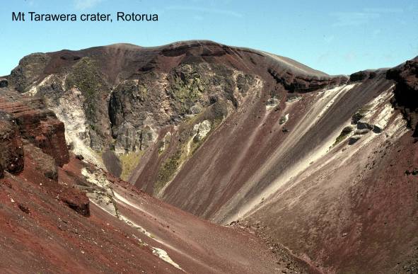
Awakeri Hot Springs. Map:
V15; Classification: C1. Significance:
Bowditchs Quarry tephra section. Map: V15;
Classification: B3. Significance: Type locality for Mangaone
Tephra.
Bowentown tombolo and dune sequence. Map: U13; Classification: C3.
Significance: One of the best examples of a tombolo
in the western Bay of Plenty.
Earthquake Flat craters and fault swarm. Map:
U16; Classification: B3. Significance: Earthquake Flat is the largest of a 5 km
line of explosion craters along a fissure.
Earthquake Flat tomo. Map: U16; Classification: C3. Significance: A tomo in Taupo pumice.
Edgecumbe Fault
scarp preservation site. Map: V15; Classification: B1. Significance: Only
remaining trace of the Edgecumbe Fault (ruptured on
Edgecumbe volcano. Map: V16; Classification: C3. Significance:
Multiple vent andesitedacite volcano
in northern segment of Taupo Volcanic Zone.
Fairy Springs. Map:
U16; Classification: C2. Significance: Spectacular scenic springs of cool clear
freshwater bubbling up through dancing pumice sands in a bush-clad grotto.
Forestry road ignimbrite
section, off
Golden Springs. Map:
U17; Classification: C2. Significance:
Hamurana Springs. Map: U15; Classification: C2. Significance:
Spectacular scenic springs of cool freshwater bubbling out of pumice substrata.
Hinemoa Point lava dome. Map: U16; Classification: C3. Significance: Rhyolite lava dome erupted after formation of Rotorua Caldera.
Kaharoa Pyroclastics section. Map: V16;
Classification: B3. Significance: Type locality for Kaharoa
Pyroclastics.
Kaiate Falls. Map:
U14; Classification: C3. Significance: One of the most spectacular and highest
waterfalls in the
Kaingaroa shelter petroglyphs. Map: V17;
Classification: B2. Significance: Largest and most important petroglyph site in the
Kauri Pt Pleistocene
cross-bedded marine sediments. Map: U13; Classification: C2.
Significance: Excellent exposures of highly unusual cross-bedded banded sands
of shallow marine origin with occasional trace fossils. Possibly
flood-tidal delta sediments that accumulated in sand banks inside entrance of
Kawaha Point rhyolite dome. Map: U16; Classification: C3.
Significance:
Kawerau Geothermal Field. Map: V15; Classification: C2.
Significance:
Kerosene Creek hot waterfall. Map: U16;
Classification: C2. Significance: One of best examples of a hot waterfall in
Kuirau Lake. Map: U16; Classification: B1. Significance:
Largest discharge feature in Rotorua, outside of Whakarewarewa.
Maketu estuarine lagoon. Map: V14; Classification: C2.
Significance: A well-defined mesotidal estuarine
lagoon.
Maketu sandspit. Map: V14; Classification: C3. Significance: One
of the best preserved and least modified sandspits
along the
Maketu Hot Springs.
Map: V14; Classification: C2. Significance:
Mamaku ignimbrite tors. Map: U15;
Classification: B1. Significance: Spectacular road side landforms of baffling
origin
Mangakotukutuku Springs. Map: V16; Classification: C2. Significance:
Mangakotukutuku Stream pyroclastic section. Map:
V16; Classification: C3. Significance: Type locality for Te Haehaenga
Pyroclastics.
Mangakotukutuku Stream valley ignimbrite section. Map: V16; Classification:
C3. Significance: Type locality for Whakatane
Formation.
Maraenui escarpment. Map: X15; Classification: C3. Significance:
Impressive, unusually steep section of coastline.
Matakana foredune barrier island. Map: U14;
Classification: B3. Significance: An example of a marine feature rare to
Matata Fault. Map:
V15; Classification: C2. Significance: Best example of late Holocene
displacements on the Matata Fault. Displacement is
normal, with at least 3 earthquakes occurring in past few thousand years. Important site in recognition of active western margin of Taupo Volcanic Zone.
Matata Lagoon. Map: V15; Classification: C3. Significance: One
of the best examples of a coastal lagoon in the
Matata Pleistocene marine sequence and fossils. Map: V15;
Classification: B3. Significance: Best exposed sequence of marine Pleistocene
in northern
Matuatonga, carved rhyolite 'kumara god',
Mauao,
Maungakakaramea lava
dome (Rainbow Mountain). Map: U16; Classification: B3. Significance: Dacite dome erupted to SW of Okataina
Centre.
Maungaongaonga lava dome. Map: U16; Classification: C3. Significance: Dacite dome erupted to SW of Okataina
Volcanic Centre.
Motu gorge. Map: X15; Classification: B3. Significance: A deeply
incised gorge up to 40 m deep, flowing through virgin indiginous bush.
Motu River delta. Map: X15; Classification: C3. Significance:
Largest river delta in the
Mt Maunganui dome. Map: U14; Classification: B3. Significance:
Remnant of a large rhyolite lava dome
Mt Ngongotaha lava
dome. Map: U16; Classification: C3. Significance: Rhyolitic
lava dome complex erupted within Rotorua Caldera.
Murupara-Kawerau railway cutting tephra section.
Map: V16; Classification: C3. Significance: Type locality for Tahuna Tephra and Ngamotu Tephra.
Ngapuna Spring. Map: U16; Classification: B1. Significance: Second
largest dicharging spring outside of Whakarewarewa.
Ngapuri Fault, neighbouring traces. Map: U17; Classification: C3.
Significance: Recent fault scarp displacing Hinuera
Formation (20000 years) by c.5 m (NW side up). Displacement
rate c.0.25 mmy. Fault traces show W side
step.
Ohinemutu-Kuirau geothermal area. Map: U16; Classification: C1.
Significance: Activity now severely reduced due to exploitation in the field.
Ohiwa Harbour Pleistocene fossils. Map:
W15; Classification: B3. Significance: Very diverse, open-water molluscan fauna.
Ohope barrier spit and dune ridges. Map: W15; Classification: C2.
Significance: Good example of a late Holocene barrier spit with associated
series of dune ridges.
Ohope Beach
Pleistocene marine sediments and Ohope shell bed.
Map: W15; Classification: B3. Significance: Good exposure of northern
Okahu Point shore
platform, Te Kaha. Map: X15; Classification: C3.
Significance: One of the most extensive,
most accessible and least rugged shore platforms on the west coast of
Okareka Tephra section. Map: U16;
Classification: C3. Significance: Type locality for Okareka
Tephra.
Okataina Springs. Map: V16; Classification: C2. Significance:
Old
Omokoroa Pt peat-ignimbrite section. Map: U14; Classification: C2.
Significance: Best exposure of sequence of Pleistocene peat overlain by
ignimbrite representative of local
Onepu lava domes. Map: V15; Classification: C3. Significance:
Young lava domes associated with intense geothermal system.
Opotiki Cliffs Pleistocene tephras. Map:
W15; Classification: B4. Significance: Best exposures of mid-Pleistocene tephras in eastern
Paeroa Fault Zone. Map: U16; Classification: C3. Significance:
Recent fault traces on the Paeroa Fault Zone that
cross cut line of Reporoa lateral pipeline. 8 traces in site area trending NE, with recent collapse gully
lineaments common along line of fault.
Papamoa relict foredune plain. Map: U14;
Classification: B3. Significance: Potentially one of the most complete records
of Holocene coastal plain evolution in the
Pukehinau (Waikokopu) Hot Springs. Map: V16; Classification: C2.
Significance:
Pukeroa (Hospital Hill) lava dome. Map: U16; Classification: C3.
Significance: Rhyolite dome erupted after formation
of Rotorua Caldera.
Rangitaiki Plains cuspate foreland. Map: W15; Classification: C2.
Significance: A good example of an actively prograding
cuspate foreland with associated parallel and parabolic dunes.
Reporoa Geothermal Field. Map: U17; Classification: C2.
Significance:
Rerewhakaaitu Pyroclastics section. Map: V16;
Classification: C3. Significance: Type locality for Rerewhakaaitu
Pyroclastics.
Rotoiti Geothermal Field. Map: V15; Classification: C2.
Significance:
Rotoitipakau Faults
(Bookers 1987 trace). Map: V15; Classification: C2. Significance:
Rotokawau basalt. Map: U15; Classification: B3. Significance:
Basaltic pyroclastic eruption from Okataina Volcanic Centre.
Rotoma Geothermal Field. Map: V15; Classification: C2.
Significance:
Rotoma Volcanic Complex. Map: V15; Classification: B3.
Significance: Holocene dome complex occupying Rotoma
caldera within Okataina Volcanic Centre.
Rotomahana Pyroclastics section. Map: V16;
Classification: A3. Significance: Type locality for Rotomahana
Pyroclastics.
Rotorua Geothermal Field. Map: U16; Classification: A1.
Significance: Contains only major geyser field remaining in
Ruatahuna Fault.
Map: W17; Classification: C3. Significance: Very good example of late
Quaternary displacement on the Ruatahuna Fault (6.1 m
RL).
Sapphire (Katikati)
Hot Springs. Map: T14; Classification: C2. Significance:
Savage Road Okareka basalt section. Map: V16; Classification:
C3. Significance: Coarsest scoria sample from Okareka
basalt indicating proximity to source.
Taheke Geothermal Field. Map: U15; Classification: C2.
Significance:
Tapuaeharuru Pyroclastics section. Map: V15;
Classification: C3. Significance: Type locality for Tapuaeharuru
Pyroclastics.
Tarawera 1886 fissure. Map: V16; Classification: A2. Significance: A
rift of aligned craters developed across Mt Tarawera
during the largest historical eruption from Taupo
Volcanic Zone in 1886 AD. This site is monitored for precise strain
measurements by the Earth Deformation Section,
Tarawera basalt. Map: V16; Classification: A3. Significance: Only
historical deposit from a
Tarawera Falls. Map:
V16; Classification: C3. Significance: Best example in
Tarawera River Matahi basalt section. Map: V16;
Classification: C3. Significance: Type locality for Matahi
basalt.
Tarawera Volcanic Complex. Map: V16; Classification: A3.
Significance: Volcanic complex constructed within Haroharo
Caldera by eruption of rhyolite lavas and pyroclastics during the last 18 ka.
Taumaihi Island boulder tombolo. Map: V14;
Classification: C3. Significance: Only example in the
Taupiro Point sandspit. Map: U13; Classification: C3. Significance:
Excellent example of a Holocene sandspit built across
an inlet entrance.
Te Kaha folded melange. Map: X14; Classification: C3. Significance: A good
example of a structural melange.
Te Mu Road section. Map:
U16; Classification: C3. Significance: Type locality for Rotorua
Pyroclastics.
Te Ngae Road tephra section. Map: U15; Classification: B3. Significance:
Standard reference section through Late Quaternary tephras
erupted from Okataina Volcanic Centre.
Te Papa Terrace. Map: Y14; Classification: C3. Significance: One
of the best preserved areas of uplifted marine terraces in the eastern
Te Piki
Pleistocene fauna,
Te Wairoa buried
village. Map: U16; Classification: B2. Significance: Most easily interpreted
relics from New Zealand's largest historic volcanic eruption.
Te Whekau crater.
Map: U16; Classification: B3. Significance: Large, young explosion crater with
associated poorly exposed explosion breccia deposits.
Tikitapu Volcanic
Complex. Map: U16; Classification: B3. Significance: Holocene dome complex
within Okataina Volcanic Centre.
Tikitere Geothermal
Field. Map:
U15; Classification: B2. Significance:
Tumunui lava dome. Map: U16; Classification:
B3. Significance:
Utahina fossil geothermal site. Map: U16;
Classification: C2. Significance:
Waiaute Springs. Map: V16; Classification: C2.
Significance:
Waihau Bay shore
platform. Map: Y14; Classification: B3. Significance: Excellent example of a
shore platform of steeply dipping, folded and faulted
alternating sandstone and siltstone.
Waihi Beach. Map:
U13; Classification: C2. Significance: An excellent example of a beach showing
classic characteristics of long term erosion.
Waikanapanapa wave-cut platform, cliffs and sea caves. Map: Y14;
Classification: C3. Significance: Impressive wave-cut shore platform and
cliffs, formed in the only coastal soft-rock in the
Waikimihia (Hinemoa's Pool) thermal bathing pool,
Waimangu Geothermal Field. Map: U16; Classification: A2.
Significance: 1) All features have formed in historic times, as a consequence
of volcanic eruption. 2) Waimangu represents a
totally undisturbed hot chloride water system. 3) The unique quasi-cyclic behaviour involving complicated changes in level and
outflow from the two lakes. 4) Includes pyroclastic
deposit associated with the largest historical eruption from the Taupo Volcanic Zone, the 1886 AD Tarawera-Rotomahana-Waimangu
eruption.
Waimangu Valley 1886
craters. Map: U16; Classification: A2. Significance: Site of the only geyser
field in the world activated in historic times. Series of explosion craters
formed during Tarawera 1886 AD eruption and marking
the SW extreme of activity.
Waimangu Valley, Black
Crater. Map: U16; Classification: B3. Significance:
Waimangu Valley,
Echo Crater (Frying Pan Lake). Map: U16; Classification: A2. Significance:
Frying-pan Lake is a major feature with a unique sympathetic relationship to
Inferno Crater Lake. Volcanic crater formed during the 1886 AD Tarawera eruption infilled by the
largest hot lake in New Zealand fed by numerous boiling and near-boiling
springs.
Waimangu Valley,
Fairy Crater. Map: U16; Classification: C3. Significance:
Waimangu Valley,
Inferno Crater. Map: U16; Classification: A2. Significance: Unique fluctuating
discharge pattern.
Waimangu Valley, Raupo Pond Crater. Map: U16; Classification: C2.
Significance:
Waimangu Valley,
Southern Crater. Map: U16; Classification: B3. Significance:
Waimangu Valley, Warbrick Terrace. Map: U16; Classification: B2.
Significance:
Waiohau Fault Zone, Mangamako Stream, Waiohau
Basin. Map:
V16; Classification: C3. Significance: Trench site and exposure of the Waiohau Fault Zone on N side. Shows 3 m (W side down)
displacement and fault plane dip of 70-80 degrees W. Considered to be reverse
oblique slip fault with dominantly W side up motion. Fault zone has been active
in last c.5000 years.
Waiohau Fault Zone, Rangitaiki River, Waiohau
Basin. Map:
V16; Classification: C3. Significance: Tectonic basin formed by E side stepping
of the Waiohau Fault (active within last 50000
years).
Waiohau Pyroclastics section. Map: V16; Classification:
C3. Significance:
Type locality for Waiohau Pyroclastics.
Waiotahi sandspit and estuary. Map: W15;
Classification: C2. Significance: One of the most picturesque and unspoiled sandspits and estuaries in the eastern
Waiotapu collapse
craters. Map: U16; Classification: C3. Significance:
Waiotapu Geothermal Field. Map: U16; Classification: A2.
Significance: 1) Extensive set of collapse pits. 2) Large alkaline spring with
sinter terrace. 3) Large number of recent hydrothermal explosion craters.
Waiotapu halotrichite.
Map: U16; Classification: C3. Significance: A good deposit of halotrichite.
Waiotapu, Artist's Palette-Primrose Terraces. Map: U16;
Classification: A2. Significance: Largest, finest active silica terrace in New
Zealand, with associated amorphous metallic sulphides.
Widely quoted model for epithermal gold systems.
Waiotapu, Champagne
Pool geothermal sinter. Map: U16; Classification: A2. Significance: Most
striking hot pool in New Zealand. A world-class example of minerals associated
with a geothermal sinter - amorphous metallic sulphides
precipitating with the sinter surrounding Champagne Pool.
Waiotapu, Devils
Inkpot acidic pool. Map: U16; Classification: C2. Significance:
Waiotapu, Echo Lake
(Whangioterangi) explosion crater. Map: U16;
Classification: C2. Significance:
Waiotapu, Lady Knox
Geyser. Map: U16; Classification: B2. Significance:
Waiotapu, Loop Road
Mud Volcano. Map: U16; Classification: B2. Significance:
Waiotapu, Rainbow
Crater mudpools. Map: U16; Classification: B2.
Significance:
West Rerewhakaaitu
fissures. Map: V16; Classification: B3. Significance: Two en echelon alignments
of 10 ka explosion vents.
Whakarewarewa,
Kereru Geyser. Map: U16; Classification: A1. Significance:
Whakarewarewa, Korotiotio boiling springs. Map: U16; Classification: B1.
Significance:
Whakarewarewa, Mahanga Geyser. Map: U16; Classification: A1. Significance:
One of the last cluster of large geysers in New Zealand.
Whakarewarewa, Ngamokaiakoko (Frog Pond). Map: U16; Classification: B1.
Significance:
Whakarewarewa, Ngararatuatara boiling pool. Map: U16; Classification: B1.
Significance: Western most flowing spring at Whakarewarewa.
Whakarewarewa, Ororea group of springs. Map: U16; Classification: B1.
Significance: Largest boiling springs in vicinity of Lake Roto-a-Tamaheke.
Whakarewarewa, Papakura "Geyser". Map: U16; Classification: B1.
Significance:
Whakarewarewa, Parekohoru hot pool. Map: U16; Classification: B1. Significance:
Whakarewarewa, Pohutu Geyser. Map: U16; Classification: A1. Significance:
A world-ranking geyser and unique attraction.
Whakarewarewa,
Prince of Wales Feathers Geyser. Map: U16; Classification: A1. Significance:
One of the last cluster of large geysers in New Zealand.
Whakarewarewa, Puapua Geyser. Map: U16; Classification: B1. Significance:
Whakarewarewa, Roto-a-Tamaheke hot springs. Map: U16; Classification: A1.
Significance:
Whakarewarewa, Te Horu cauldron. Map: U16; Classification: A1. Significance:
Directly connected to the reservoir for Pohutu
geyser.
Whakarewarewa, Waikite Geyser. Map: U16; Classification: B1. Significance:
Currently geyser not active.
Whakarewarewa, Waikorohihi Geyser. Map: U16; Classification: A1.
Significance: One of the last cluster of large geysers in New Zealand.
Whakarewarewa, Wairoa Geyser. Map: U16; Classification: C1. Significance:
Geyser throat and deposits are perfectly preserved.
Whakatane Fault and Ruatahuna Fault. Map: W17; Classification: C3. Significance:
Example of Whakatane and Ruatahuna
Fault offset of Torlesse greywacke. Narrow horst block between faults.
Whale Island East Dome. Map: W15;
Classification: C3. Significance:
Whale Island Geothermal Field. Map: W15;
Classification: C2. Significance:
Whale Island sulphur
processing site. Map: W15; Classification: C2. Significance: A relic of early
attempts to mine sulphur.
Whale Island volcano. Map: W15;
Classification: C3. Significance: Dacite-andesite
volcano in northern segment of Taupo Volcanic Zone.
Whale Island West dome. Map: W15;
Classification: C3. Significance:
Whangairorohea Hot
Springs. Map: U17; Classification: C2. Significance:
Whangaparaoa dune field and wetlands. Map: Y14; Classification: C2.
Significance: Largest dune field and associated wetlands in northwestern
White Island Donald Mound. Map: W13;
Classification: A3. Significance: Site of persistent fumerolic
activity in main crater of White Island.
White Island Geothermal Field. Map: W13;
Classification: A1. Significance: Highly acidic hydrothermal system associated
with andesitic volcanism.
White Island Noisy Nellie Crater. Map: W13;
Classification: B3. Significance: Historical crater on White Island.
White Island sulphur
workings. Map: W14; Classification: B2. Significance: New Zealand's best
example of veins and pockets of actively depositing fumarolic
sulphur in an active volcano. First sulphur to be exported from New Zealand (1865) came from
here. Also site of eruption that killed all sulphur
workers in 1914.
White Island volcano. Map: W13;
Classification: A2. Significance: Most active volcano in New Zealand since
1976, incorporating a Category A high temperature geothermal field.
White Terraces site. Map: V16; Classification: C5. Significance: Site
of one of the two most famous geothermal features in New Zealand, destroyed by
the 1886 Tarawera eruption.
Woodlands (Katikati)
Hot Springs. Map: T13; Classification: C1. Significance: